Author page hero image

About Author

Sudip Sahoo

Sudip Sahoo

Author

Sudip’s Work

Summer Ladakh Trip vs Winter Ladakh Trip – Which Experience Is Better?
May 25, 202610 Minutes
Summer Ladakh Trip vs Winter Ladakh Trip – Which Experience Is Better?
Someone books a Ladakh trip, spends three weekends researching hotels, obsesses over the packing list, and then just... picks dates randomly. June because a friend went in June. Or December, because the photos looked nice. That is honestly how most Ladakh trips get planned, and it is also why so many people come back saying "it was okay, but not what I expected."Here is the thing. Ladakh in summer and Ladakh in winter are not the same place. Not even close. And if you pick the wrong season for what you actually want, no amount of good Leh Ladakh tour packages will save the experience. So let's talk about both, honestly, without the usual travel blog cheerfulness.What Ladakh Looks Like in SummerMay, June, July, August, September. These five months are when Ladakh becomes the version you see in every photo. Pangong Tso actually looks blue (in winter, it's a frozen white slab). Nubra Valley has those weird double-humped camels walking around like it's perfectly normal. The roads are open. Monasteries have people in them. Dhabas are serving hot food by 7 am.There is a certain energy to summer Ladakh that is hard to describe without sounding cliché. Villages that were completely shut for five months suddenly wake up. Guesthouses fill. Local kids are out. The mountains don't change, but everything around them does.Ladakh Temperature in SummerDaytime sits between 15°C and 25°C across most of the region. Sounds perfect, and it mostly is. But nights are a different story. Even in July, once the sun goes down, temperatures can drop to 8°C or lower. Pack a proper jacket regardless of what month you go. The sun is also deceptively strong at this altitude, carry sunscreen you would not normally bother with at home.WeatherJuly and August are technically monsoon months for the rest of India. Ladakh doesn't care. The Himalayas block most of that moisture from reaching here, so the region stays dry while everything south of it is soaked. You'll see maybe one or two brief showers across a week-long trip. Nothing trip-ruining. The sky stays clear enough that you'll genuinely wonder if clouds exist.Road ConditionsThe Manali-Leh Highway opens around late May, sometimes early June, depending on snowmelt. The Srinagar-Leh Highway runs through most of the summer and is generally reliable. Both stay open well into September, sometimes early October. This matters enormously. In Ladakh, a road being "closed" doesn't mean you take a longer route. It means that the place simply doesn't exist for you that day. No Pangong. No Nubra. You sit in Leh and stare at the walls.Also Read: Manali vs Srinagar Route – Which is Better for Ladakh Trip?Famous Festivals CelebratedHemis Festival in June or July is the one worth planning around. Held at Hemis Monastery, it is the largest monastic festival in Ladakh, with masked dances, traditional music, and an atmosphere that doesn't feel performed for tourists. It feels real because it is real. The Sindhu Darshan Festival in June celebrates the Indus River and brings a certain festive chaos to Leh. Come August and September, the Ladakh Festival spreads across Leh with polo matches, archery, and folk performances. If cultural experiences are part of why you want to go, summer is the only season that actually delivers them.What Ladakh Looks Like in WinterWinter in Ladakh covers October through March. Let's be straight about this. Winter Ladakh is not a more peaceful version of summer Ladakh. It is an entirely different trip that suits an entirely different kind of traveler.By November, the tourist shops are shuttered. By December, the roads out of Leh are gone. The silence is something people either find deeply moving or deeply inconvenient, depending on what they came for.The Temperature of Ladakh in WinterOctober starts around -5°C to -10°C, and that's the mild part. January and February regularly see -20°C to -30°C in Leh. Not "cold, wear a puffer" cold. The kind of cold where your phone dies in twenty minutes outside, water freezes in your hotel room overnight if the heating fails, and stepping out without proper gear is genuinely dangerous. Pangong Tso turns completely solid. You can walk on it, which is surreal, but you're also standing at 14,000 feet in -25°C, so surreal has a cost.WeatherHeavy snowfall runs from December through February. Visibility on the roads that are still open (mostly within Leh town) can drop badly. The sun does come out on clear days, and it is beautiful in a stark, almost violent way. But you cannot plan around it. Cloud cover can sit for days. AMS is still very much a risk in winter, which surprises a lot of first-time winter visitors. Cold does not protect you from altitude. Your body still needs time to adjust, and it is working harder in the cold on top of that.Road ConditionsThe Manali-Leh Highway closes by late October or November. The Srinagar-Leh Highway goes around the same time. Flying into Leh is your only real option from November to April. And once you are in Leh, where you can go is sharply limited. Pangong is technically reachable on some days but it takes serious planning and the right vehicle. Nubra becomes very difficult. Your world shrinks to Leh town and a few nearby monasteries.Famous Festivals CelebratedChadar Trek from January to February is the headline act. Trekkers walk the frozen Zanskar River for several days, camping on the ice at night. It is one of those trips people talk about for years. But it is not for people who have never trekked before. The physical and mental demands are real. The Losar Festival (Ladakhi New Year) falls in January or February and is celebrated quietly within local communities. Worth witnessing if you can access it, but don't expect the open-air spectacle of summer festivals.Final Decision: Which Season Is Better, Winter or Summer?Summer. And here is why that answer is not even close.Roads are open. You can get to Pangong, Nubra, Khardung La, and Zanskar. You can actually do the things people go to Ladakh for. Camel safari in Hunder. Rafting on the Indus. Watching the Hemis festival in a monastery courtyard. Stargazing in Hanle. None of that is properly accessible in winter.Your body handles the altitude better, too. At -25°C, you are dealing with altitude and extreme cold at the same time. That is two things hitting you simultaneously, and it makes acclimatisation harder, not easier.Budget-wise, summer Ladakh tour packages start at around ₹20,000 per person for a decent 6 to 7-night trip and go up to ₹45,000 for more comfortable options with flights and internal travel included. That range gives you real flexibility.Winter is worth doing. But only with a specific reason. Chadar Trek. Snow Leopard. Frozen lake photography. If you don't have a clear purpose that only winter serves, you are making the trip harder than it needs to be. Closed roads, limited food, extreme cold, and a town that is essentially half asleep is not a holiday. It is an expedition.Go in the summer. See Ladakh first. Then, if you want to come back for winter, you'll know exactly what you are signing up for.If you are planning to visit Ladakh, read these best Places to visit in Ladakh & Things to do in Ladakh.

Read More

Road Trip Routes in Meghalaya: Distances, Costs, and What to Expect
May 25, 202616 Minutes
Road Trip Routes in Meghalaya: Distances, Costs, and What to Expect
Nobody warns you about the fog. You are driving somewhere near Cherrapunji, visibility drops to maybe 10 meters, and suddenly the road just stops being visible. That is Meghalaya. Beautiful, slightly unpredictable, and nothing like what the travel blogs describe.Most people land in Guwahati, spend a night in Shillong, see Elephant Falls, and fly back home, calling it a Meghalaya trip. That is not a road trip. That is a pit stop with a hotel room.If you are actually planning a Meghalaya road trip, this is the guide that covers real distances, real road conditions, and costs in INR without padding the numbers.The best road trip routes in Meghalaya run between Shillong and Cherrapunji (55 km), Shillong and Dawki (82 km), and Shillong and Mawlynnong (90 km). Most are drivable in a standard hatchback. October to April is the safest driving window. Monsoon months get roads blocked by landslides, sometimes for days. Why Meghalaya Actually Works as a Road TripThe state sits in northeast India, Assam to the north, and Bangladesh pressing in from the south. Almost entirely hilly. Which sounds obvious until you are actually driving it and realize that every 20 km brings a different kind of landscape.Roads on NH6 and around Shillong are decent. State roads heading toward waterfalls and border villages? Hit or miss, especially after heavy rain. Standard cars manage most routes fine. Anything heading toward Balpakram in the Garo Hills, take an SUV and don't debate it. The real reason Meghalaya tour packages work for road trips is simple. You don't drive long stretches between interesting things. Thirty to forty kilometers, and something new shows up. That rhythm is hard to find anywhere else in India. Let's see some road trips1. Shillong to Cherrapunji Road TripDistance: 55 km. Drive time: 1.5 to 2 hours.Start on NH6 out of Shillong. Pine forests first, then the road starts descending toward Sohra, which is what locals actually call Cherrapunji. Valley views open up on both sides. On a clear day, you can see Bangladesh in the distance.Stop at Mawkdok Dympep Valley Viewpoint halfway. Worth 20 minutes. Don't rush past it.Nohkalikai Falls near Cherrapunji is India's tallest plunge waterfall at 340 meters. Monsoon season fills it. Outside the monsoon, it still runs but thinner. Road conditions during the monsoon get complicated, with fog, wet roads, and occasional blocks. If you want both good roads and decent waterfalls, October to early November is the sweet spot.Fuel one way from Shillong: ₹300 to ₹500. Day cab hire: ₹2,500 to ₹4,000.2. Shillong to Dawki and ShnongpdengDistance: 82 km. Drive time: 2.5 to 3 hours.Dawki is on the Bangladesh border. The Umngot River runs through it. And the water is genuinely transparent, not just clear but see-through like glass. Boats floating above the riverbed look suspended in air. Every photo you have seen is real, not edited.The descent through Jaintia Hills is steep in parts. Narrow too. First-time drivers on hilly roads should go slow and not trust the timeline too much. The descent alone can take longer than expected.Shnongpdeng sits a few kilometers from Dawki. Less crowded, better for overnight camps, cliff jumping, kayaking. If you have an extra day, stay here instead of rushing back.Jowai is roughly midway. Local food there is worth a stop. Thadlaskein Lake nearby if you have time.Cab return from Shillong: ₹3,500 to ₹5,500. Boat ride at Dawki: ₹100 to ₹200 per person.3. Shillong to Mawlynnong and Living Root BridgesDistance: 90 km. Drive time: 2.5 to 3 hours.Asia's cleanest village title gets used as a marketing line so often it loses meaning. Then you actually arrive and the roads are swept, bamboo dustbins every few meters, no litter anywhere. It is maintained at a level that feels almost competitive.The living root bridges at Riwai are about 1 km from the village. Rubber fig tree roots trained for generations to grow across streams and form actual functional bridges. The Riwai one is a short walk. The famous double-decker near Nongriat requires a serious trek, 3,500 steps down and back up.Most people do Mawlynnong and Dawki together since they fall in the same direction from Shillong. Two days is the right call. One day is possible but you will feel like you skimmed everything.Full loop cab hire: ₹5,000 to ₹7,500.4. Shillong to Nohkalikai Falls and NongriatDistance: 58 km. Drive time: 2 hours.This one gets grouped with Cherrapunji but deserves separate treatment. The falls viewpoint is right off the road, five minutes from the parking. That part is easy.Nongriat village, with the double-decker living root bridge, is a different story entirely. Seven km trek each way from Tyrna village, roughly 5 km before the falls. Steep. Humid. Around 3,500 steps down, same back up. Don't underestimate it. But the bridge at the bottom is unlike anything else in India, worth every step.July to October for peak waterfall flow. Guide hire at Tyrna: ₹500 to ₹800. Don't skip the guide.5. Shillong to Mawphlang Sacred Grove and SmitDistance: 25 km. Drive time: 45 minutes.Mawphlang is the one most travelers skip because it doesn't photograph dramatically. That's exactly why it's worth going.The sacred grove is a forest that the Khasi community has protected for centuries. Nothing removed, nothing cut. Ancient monoliths sitting under moss-covered trees. Guided entry is mandatory. Pay the ₹500 to ₹800, listen properly, and you will understand what you are standing inside. Skip the guide, and you are just walking through trees.Smit village nearby hosts the Nongkrem Dance each November. Outside that window, it's quiet, but the traditional architecture alone makes the detour worth it.6. Jowai to Krang Suri WaterfallDistance: 65 km from Jowai. Drive time: 2 hours.Krang Suri doesn't get the attention it deserves. Turquoise pool, jungle surrounding it, and rock formations on the sides. Swimming is allowed in the dry season. Get there before 11 AM because the light hits the pool directly in the morning, and the photos from that window actually look like the real thing.The last 10 to 15 km of the road is narrow. Slow down and don't trust Google Maps timings here.Combine it with Dawki on a two-day loop from Shillong through Jowai. That circuit makes geographical sense and covers a lot without feeling rushed.Entry: ₹50.Parking: ₹50.7. Getting to Meghalaya from GuwahatiGuwahati to Shillong is 100 km on NH6. Around 2.5 to 3 hours. Traffic near Guwahati in the morning and around Nongpoh slows things. Start early if you can.Self-driving is fine on main routes if hills don't stress you out. Local cab drivers know the roads in a way that genuinely matters on smaller routes, not just for directions but for knowing which roads flood and which viewpoints close early. Cab hire in Shillong runs ₹2,500 to ₹4,500 per day.Indian citizens don't need special permits for most destinations. The Dawki border area requires ID proof at checkpoints. Carry your Aadhaar or passport.Best Time to Drive in MeghalayaOctober to February. That's the answer most of the time. Dry roads, clear skies, Shillong sitting between 5°C and 20°C. Crowded around Christmas and New Year, but still the most reliable window.March to May is underrated. Fewer tourists, warmer temperatures, and roads in good shape. Waterfalls lose some volume, but the drives are cleaner.June to September is monsoon. Cherrapunji gets some of the highest rainfall anywhere on earth during this stretch. Waterfalls go full power. Roads flood, get blocked, and sometimes close for days. If you go during monsoon, start every drive early in the morning, build buffer days into the plan, and never drive state roads after dark.Cost Breakdown for a Meghalaya Road TripA 5-day trip covering Shillong, Cherrapunji, Dawki, and Mawlynnong typically runs ₹12,000 to ₹22,000 per person before flights.Guwahati to Shillong cab one way: ₹1,500 to ₹2,500Shillong local cab per day: ₹2,500 to ₹4,500Budget guesthouse per night: ₹600 to ₹1,500Mid-range hotel per night: ₹1,500 to ₹3,500Local food per day: ₹300 to ₹700Entry fees across all spots: ₹500 to ₹1,500 totalA road trip through Meghalaya takes you across misty hills, waterfalls, and scenic valleys, making it one of the best ways to explore the top Places to Visit in Meghalaya while enjoying thrilling Things to do in Meghalaya like camping, trekking, cave exploration, and local food tasting.

Read More

Top 7 Rivers in Ladakh to Visit At Least Once
May 25, 20267 Minutes
Top 7 Rivers in Ladakh to Visit At Least Once
Rivers in Ladakh are not just water bodies flowing quietly through the mountains. The rivers here are the backbone of the region. They shape villages, fuel ancient trade routes, support local life, and create some of the most unreal landscapes you will ever see. For travelers planning for Ladakh tour packages, understanding every major Ladakh river adds a completely different layer to the journey.Having guided expeditions across this Himalayan terrain, we've witnessed how Ladakh rivers tell a story of survival, spirituality, and spectacular natural engineering. They’re the arteries sustaining one of Earth's most extreme inhabited landscapes, fed by glaciers older than recorded history. Every famous valley, monastery, camping site, and mountain pass somehow connects back to a powerful Leh Ladakh River system that keeps this high-altitude land alive.Importance of Ladakh RiversLife in Ladakh would struggle without its rivers. Agriculture, drinking water, transportation routes, and tourism activities all depend heavily on these glacial rivers flowing through the mountains. Since Ladakh receives very little rainfall, most villages survive because snow-fed rivers continue supplying fresh water even during harsh conditions.The rivers also shape Ladakh’s tourism identity. River rafting in Zanskar, camping beside the Shyok, all attract travelers searching for raw Himalayan beauty. Another interesting part is the spiritual connection. Locals consider several rivers sacred, especially the Indus River, which holds deep historical and cultural significance in Indian civilization. Many Ladakh Monasteries and ancient settlements were built near these rivers centuries ago because water meant survival.Every major river in Leh Ladakh tells a different story. Some carry legends, some create adventure, and some simply leave people speechless with their scenery.Exploring the Stunning Rivers of Ladakh1. Indus RiverThe Indus River is the heart of Ladakh’s geography and history. Originating near Mount Kailash in Tibet, this mighty river enters Ladakh and flows across valleys before continuing toward Pakistan. At 3,180 kilometers, it's one of Asia's longest rivers, sustaining the Indus Valley Civilization millennia ago. Ancient civilizations grew around the Indus, and many historians believe India got its name from this river. Several monasteries and villages in Ladakh still stand close to its banks. During summer, the contrast of clean water against barren brown mountains creates one of the most iconic views of any Ladakh river landscape.2. Zanskar RiverFew rivers in India shift personality so dramatically across seasons. Adventure lovers usually know the Zanskar River before they even visit Ladakh. Famous for the Chadar Trek during winter, this river freezes into a sheet of ice that people walk across when temperatures crash below zero. In warmer months, it transforms into a fast-flowing rafting destination packed with thrilling rapids. Summer brings Grade IV-V rapids, attracting extreme kayakers worldwide. The Zanskar Valley remains snow-isolated for seven months annually, and only flows in summers, and it makes the river even more unique.3. Shyok River"River of Death" in local dialect, the Shyok earned its terrifying name from unpredictable flash floods that historically caused major problems for travelers and settlements. Despite the intimidating name, the river creates stunning scenery along the Nubra Valley route. Many travelers driving toward Turtuk or Diskit Monastery spend hours here, stopping for photographs along this beautiful Leh Ladakh River stretch. It flows through Nubra Valley before joining the Indus near Skardu (Pakistan). Wide riverbeds, sandy landscapes, and snow-covered peaks together create views that almost feel unreal. 4. Suru RiverFlowing through the Suru Valley in the Kargil district, the Suru River brings a softer and greener side of Ladakh that surprises many visitors. Unlike the cold desert appearance common in Leh, this valley features farms, villages, and mountain fields nourished by the river. The Suru River originates from the Panzella Glacier and supports local agriculture throughout the region. Travelers heading toward Rangdum often describe this route as one of Ladakh’s most peaceful drives because the river stays beside the road for long stretches.5. Nubra RiverThe Nubra River quietly shapes the famous Nubra Valley, one of the most visited regions in Ladakh. Formed by glacier melt from the Siachen area, this river supports villages surrounded by sand dunes and high-altitude mountains. The unusual mix of cold desert terrain and flowing water gives Nubra Valley its unique character. Double-humped Bactrian camels found here also exist because old trade routes once passed near this Ladakh river valley connecting Central Asia and Ladakh through ancient caravan networks, and these camels are the proof for that, as they are not native to Ladakh.6. Markha RiverThe Markha River is closely linked with trekking culture in Ladakh. People attempting the popular Markha Valley Trek cross this river on foot multiple times while walking through remote villages and mountain trails. Unlike larger rivers, Markha is more intimate and raw, surrounded by cliffs and hidden settlements. his tributary of the Zanskar begins in Nimaling's high pastures and flows through a cultural tapestry of remote villages like Skiu, Markha, and Hankar, where traditional Ladakhi life persists unchanged. Trekkers often camp beside the river after exhausting hiking days. During summer, the valley around the river becomes one of the best examples of untouched Himalayan beauty, and blue sheep and Himalayan marmots frequent the riverbanks, while the occasional snow leopard pug mark reminds trekkers they're in predator territory.7. Drass RiverThe Drass River flows through one of the coldest inhabited regions in the world, the town of Drass at 3,230 meters. Fed by glacier systems in the Himalayas, this river eventually joins the Suru River near Kargil. Fed by surrounding glaciers, the Drass River flows through the war-scarred Drass Valley where the 1999 Kargil War raged. Winter temperatures here regularly hit -45°C, freezing the river solid for six months. When summer arrives, the river in Ladakh becomes a raging torrent carrying glacial sediment that enriches valley farmlands, enabling short-season crops. Today, travelers passing through Drass often stop to admire the river flowing quietly between harsh mountain terrain. The peaceful scenery around it feels very different from the intense history connected to this area.If you are planning to visit Ladakh, read these best Places to visit in Ladakh & Things to do in Ladakh.

Read More

Solo Girls' Trip to Meghalaya – Here's What You Get to See in 2026
May 25, 202615 Minutes
Solo Girls' Trip to Meghalaya – Here's What You Get to See in 2026
Meghalaya has something different that you will not find in the rest of India. The moment you arrive in Shillong, you will know. The smell of rain-soaked earth and pine trees. Something just shifts inside you. No loud traffic. No pushing crowds. Just clouds sitting low over green hills and a quietness that feels almost foreign after city life.And the best part nobody tells you before you go? Meghalaya is genuinely one of the safest places in India for women traveling solo. The state is matrilineal, meaning women hold real social standing here. Most shops are run by women. So if your friends backed out at the last minute or you just decided to go alone, good. Meghalaya rewards that kind of decision. Meghalaya tour packages start from around ₹23,999 per person for 4 to 5 days. Covering Shillong, Cherrapunji, Dawki, and Mawlynnong with stays and transport sorted.4-Day Itinerary for Solo Female TravellersAs a solo traveller, you can follow the Meghalaya solo trip itinerary. It is safe for solo or female bothDay 1: Land in Shillong, Find Your FeetThe travelers who come from different parts of India. First, they fly into Guwahati and then drive to Shillong. Direct flights to Shillong exist but cost significantly more, so the Guwahati route is the smarter call. Stop at Umiam Lake on the way in. Golden hour is calm, green, and completely crowd-free.You will reach Shillong by afternoon. Don't overplan Day 1. Check into your stay, eat something warm, and walk through the Police Bazaar in the evening. Khasi street food, local stalls, city energy. That one walk tells you everything about why Shillong has its own personality.Places to visit: Umiam Lake, Police BazaarDay 2: Cherrapunji and the Root BridgesWake up early. Drive to Cherrapunji, around 54 km from Shillong. The road cuts through Mawkdok Valley, a sweeping green canyon that makes every kilometer worth it. Nohkalikai Falls drops 340 metres straight down into a green pool. Standing at that viewpoint with mist on your face is something you don't forget easily.Save the afternoon for the Double Decker Living Root Bridge in Nongriat. The trek is 3,500 steps down and back up, so carry water and wear proper shoes. A private cab for the full day costs between ₹1,500 and ₹2,500. Stay overnight in Cherrapunji. Waking up inside a cloud the next morning is genuinely surreal.Places to visit: Mawkdok Valley, Nohkalikai Falls, Seven Sisters Falls, Double Decker Living Root BridgeDay 3: Dawki and MawlynnongDawki is around 80 km from Cherrapunji. The Umngot River is so clear that boats look like they are floating on glass. Get there before 10 AM. Once the tourist rush hits, the magic dips. Boat rides cost around ₹400 to ₹800 per person and are worth every rupee.From Dawki, head 30 km to Mawlynnong, Asia's cleanest village. Bamboo dustbins on every corner, swept pathways, and flowers everywhere. Climb the bamboo skywalk for views over the tree canopy and into Bangladesh on a clear day. Stay a night here if your budget allows. The homestays are warm, clean, and family-run.Places to visit: Umngot River, Dawki, Shnongpdeng, Mawlynnong Village, Sky View PointDay 4: Laitlum Canyon and ShillongStart early and stop at Laitlum Canyon before the crowds arrive. Mist still sitting in the canyon at 6 AM, no noise, no rush. That view alone is worth the early alarm. Drive back into Shillong after.Visit Elephant Falls, a three-tiered waterfall tucked inside a short forest walk, then head to Ward's Lake for a slow, quiet hour before your drive back to Guwahati. Four days, four completely different landscapes. That is Meghalaya doing exactly what it does best.Places to visit: Laitlum Canyon, Elephant Falls, Ward's Lake, Police Bazaar Things to Keep in Mind for a Solo Female Traveller in MeghalayaPre-book your cab. Don't rely on random rides, especially after sunset. Ask your homestay host for a trusted local driver. Shillong-based cab networks are reliable, and your host will almost always have a recommendation.Carry a postpaid SIM. Airtel or Jio postpaid works across Shillong and Cherrapunji. Signal drops in valley areas like Nongriat and Dawki, so download offline maps before you leave your hotel each morning.Stay at family-run homestays. Skip random budget hotels. Family homestays are warmer, safer, and honestly more fun. You get home-cooked food, local tips, and someone who actually knows you are there.Tell someone your plan. Each morning, share your day itinerary with your homestay host or a friend back home. Simple habit, big piece of mind.Dress modestly in villages. Mawlynnong and Nongriat are conservative villages. Carry a light scarf. Respectful dressing gets you warmer responses everywhere you go.Start your drives early. Roads between Dawki and Cherrapunji get narrow and poorly lit after dark. Most sights are also far more beautiful before the tourist crowd arrives anyway.Trust your instincts. If a situation feels off, walk away. Meghalaya is safe, but common sense travels with you everywhere.A Solo Girls Trip to Meghalaya is the perfect blend of adventure, peace, and freedom, where you can explore the best Places to Visit in Meghalaya while enjoying exciting Things to do in Meghalaya like waterfall hopping, café hopping, trekking, and experiencing the beauty of the clouds.

Read More

Chandratal Lake — Spiti’s Most Jaw-Dropping Secret & How to Actually Reach It
May 23, 20265 Minutes
Chandratal Lake — Spiti’s Most Jaw-Dropping Secret & How to Actually Reach It
Located in the Lahaul and Spiti region, and situated at an elevation of approximately 4,300 metres (14,100 feet), Chandratal, also called the “Moon Lake,” is famous for its changing colors, high-altitude camping experience, and raw Himalayan landscape. The lake sits near the Kunzum Pass route and remains accessible only for a few months every year because of heavy snowfall. Reaching here is not easy, and that’s why people choose Spiti Valley Packages for better safety and overall experience. With tour packages, you get throughout support, and you also travel with 20 - 25 other travelers, so the experience is even more wonderful and fun.Chandratal Lake at a GlanceLocation: Lahaul and Spiti district, Himachal PradeshAltitude: Around 14,100 ft (4,300 meters)Distance from Manali: Approx. 130 kmDistance from Kaza: Approx. 97 kmBest Months to Visit: June to SeptemberNearest Airport: Kullu–Manali AirportNearest Major Towns: Manali and KazaMobile Network: Mostly weak or unavailable near the lakeAccommodation: Campsites available near the Chandratal parking areaDirect vehicle access to the lake: Not allowed beyond the parking areaHistory and Local Legends of Chandratal LakeThe name Chandratal literally means “Lake of the Moon.” Locals believe the curved shape of the lake resembles a crescent moon, which is where the name came from. Chandratal is also linked to an old Mahabharata legend. According to local stories, this is the place where Lord Indra arrived with his chariot to take Yudhishthira to heaven. That story still gives the lake a spiritual importance among nearby villages.Apart from mythology, Chandratal Lake is environmentally important because it supports high-altitude wildlife and fragile Himalayan vegetation. The area falls under a protected wetland ecosystem, which is why permanent construction near the lake is restricted. Travelers can camp near the designated areas, but authorities do not allow camping directly beside the lake anymore.The real Spiti is hidden in its experiences, not just its views. Start with these Things to do in Spiti Valley.How to Reach Chandratal LakeReaching Chandratal is where the actual adventure begins. Google Maps may show a short distance, but mountain roads do not work like city highways. Landslides, water crossings, broken roads, and sudden weather changes can easily increase travel time.Route from Manali via Atal TunnelThis is the fastest and most common route to Chandratal.Manali → Atal Tunnel → Gramphu → Chhatru → Batal → ChandratalDistance and TimeTotal distance: Around 130 kmTravel time: 6 to 8 hours, depending on road conditionsRoad ConditionsManali to Atal Tunnel: Excellent roadAtal Tunnel to Gramphu: Mostly goodGramphu to Batal: Rough mountain road with off-road stretchesBatal to Chandratal diversion: Narrow and uneven roadSUVs and bikes handle the terrain much better than sedansTaxi and Transport CostShared taxi from Manali: ₹1500–₹3000 per personPrivate cab: ₹10,000–₹15,000 depending on vehicle typeBike rental in Manali: ₹1500–₹2500 per dayRoute from Manali via Jibhi and Jalori PassThis is not the shortest route to Chandratal, but it is calmer and more scenic for travelers who do not want to rush directly into high altitude.Manali → Kullu → Banjar → Jibhi → Jalori Pass → Rampur → Kinnaur → SpitiWhy Travelers Choose This RouteBetter altitude acclimatizationMore relaxed road trip experienceChance to explore villages like Jibhi and ShojaLess tiring compared to direct overnight ascentRoad ConditionsRoads remain decent around Kullu and Jibhi, but Jalori Pass has steep curves and narrow stretches. During the monsoon, landslides can slow traffic heavily.Travel TimeThis route usually takes multiple days(3 - 4 days) because travelers stay overnight in Jibhi, Kalpa, or Kaza before reaching Chandratal. It suits travelers who want a full Spiti circuit instead of a quick Chandratal trip.Final Stretch to Chandratal LakeVehicles cannot go directly to the lake. You must park near the designated parking area and walk around 1.5 km to reach Chandratal. The trail is mostly easy but feels tiring because of the high altitude and low oxygen levels.Older travelers, people with breathing issues, or anyone not acclimatized properly may struggle during this short walk. Carry water, avoid rushing, and walk slowly.Night walking near the lake is not recommended because temperatures drop sharply and visibility becomes poor.Best Time to Visit Chandratal LakeThe best time to visit Chandratal is from June to September, when the snow melts, the roads open, and designated campsites are operational. For the absolute clearest skies, optimal photography, and stunning stargazing, September is widely considered the prime month.June is ideal for travelers who want to see snow walls near Kunzum Pass. July and August bring greener landscapes but also higher chances of rain and landslides around Manali routes. September works best for photographers and bikers because skies stay clearer and roads become slightly safer.By October, snowfall can begin again, and the Chandratal route often becomes inaccessible for normal tourists.Key Places to Visit Near Chandratal LakeKunzum PassKunzum Pass sits at around 15,000 feet and acts as the gateway between Lahaul and Spiti Valley. Travelers usually stop here for panoramic mountain views and blessings at the small Kunzum Mata temple before continuing toward Chandratal. The air feels noticeably thinner here, and the weather changes very quickly. During early summer, huge snow walls remain visible near the road, making the drive memorable for bikers and photographers.BatalBatal is a tiny settlement famous among Spiti travelers for its rugged atmosphere and the legendary Chacha-Chachi dhaba. Most people stop here for food, tea, and rest before taking the Chandratal diversion road. Accommodation options remain basic, but the place becomes important during bad weather because it acts as a rescue and a halt point. Roads around Batal are rough, rocky, and often unpredictable, especially after rainfall or glacier melting.Losar VillageLosar is the first major village after entering the Spiti side from Kunzum Pass. Sitting at around 13,400 feet, the village offers a quieter and more traditional Himalayan atmosphere compared to crowded tourist stops. Many travelers stay overnight here for better acclimatization before heading toward Chandratal or Kaza. Small homestays, local food, and wide valley views make Losar feel peaceful without trying too hard to impress tourists.If you’re building a serious itinerary, these are the Places to Visit in Spiti Valley that matter.Things Most Travelers Do Not Know Before Visiting ChandratalThere are no luxury hotels near the lakeCamping directly beside the lake is not allowedOxygen levels drop noticeably at nightCarry cash because online payments often failMobile network is unreliable near ChandratalFuel stations are extremely limited after Manali and KazaAfternoon water crossings become stronger due to glacier meltDo not attempt night driving on this routeWeather can shift from sunny to freezing within minutesWarm jackets are necessary even during summer

Read More

Altitude Sickness in Spiti Valley - Acclimatization Tips & What Actually Helps (2026 Updated)
May 23, 20265 Minutes
Altitude Sickness in Spiti Valley - Acclimatization Tips & What Actually Helps (2026 Updated)
Every year, travelers book Spiti Valley packages, thinking the toughest challenge will be the bad roads. In reality, the bigger challenge is the Spiti Valley's height and altitude, and how your body reacts above 10,000 feet. Even experienced bikers and fit gym-goers struggle in Spiti because oxygen levels drop significantly at high altitude.And honestly, AMS is not something you should “figure out on the trip.” In 2026, despite better roads and more tourism, altitude sickness is still the number one reason why travelers cut short their Spiti plans.What is AMS in Spiti Valley?AMS in Spiti Valley stands for Acute Mountain Sickness, commonly known as altitude sickness. It is a physical condition that occurs when your body is exposed to a sudden drop in air pressure and oxygen levels due to ascending to high altitudes too rapidly.Because Spiti Valley sits at a massive elevation averaging between 10,000 to 15,000 feet (3,000 to 4,500+ meters), AMS is a very real health risk for travelers coming from lower-altitude regions.Why Altitude Sickness Happens in Spiti ValleyAs you climb higher in Spiti, the air becomes thinner, meaning your body gets less oxygen with every breath. Places like Kaza, Kibber, Langza, and Hikkim are located at very high altitudes, and your body needs time to adjust.The problem is that most travelers reach too quickly. This is why people coming from the Manali side often feel symptoms faster compared to travelers entering via Shimla and Kalpa. Your body simply doesn’t get enough time to acclimate gradually.Even updated 2026 travel advisories continue warning travelers about fast ascents in the Spiti Valley.Early AMS Symptoms You Should Never IgnoreAltitude sickness rarely starts dramatically. It begins quietly.The most common early signs include:Constant headacheDizzinessNauseaLoss of appetiteDifficulty sleepingFeeling unusually tiredShortness of breath while walkingA very real Spiti moment people talk about later is this: climbing a few hotel stairs in Kaza suddenly feels exhausting. That’s usually when travelers realize something is wrong.Bike riders especially make one mistake: they confuse AMS with road fatigue. After long hours of riding rough roads, they assume the headache and tiredness are normal. Sometimes it is. Sometimes it’s not.And that confusion becomes dangerous.Mild AMS can become severe overnight if ignored completely.Dangerous Symptoms of AMS - When You Must Descend ImmediatelyThere’s a point where “resting for some time” is no longer enough. If someone experiences these symptoms, immediate descent is important:Severe breathlessnessVomiting repeatedlyWalking imbalanceConfusionChest tightnessBlue lips or fingertipsWhat Actually Helps in Spiti Valley (Not Just Internet Advice)The internet is full of random AMS advice. Some useful, some completely useless.Here’s what genuinely helps in Spiti:1. Ascend SlowlyDon’t go to Spiti via the Atal Tunnel; the [Shimla → Kalpa → Tabo → Kaza or Manali → Jibhi → Kinnaur → Kaza] route works better for acclimatization because altitude increases gradually. It may feel slower, but your body handles it much better.2. Hydration Matters More Than You ThinkMost travelers drink less water because of the cold weather. Bad idea. Dehydration makes AMS symptoms worse. Carry water constantly, especially during road trips. Interestingly, people who stop every 10 minutes for photos often forget to hydrate properly.3. Avoid Alcohol InitiallyYour first 48 hours at high altitude matter a lot. Alcohol affects oxygen absorption and dehydration levels. Skipping drinks initially genuinely helps.4. Don’t Rush the ItinerarySlow travel works better in Spiti. Spend proper time resting instead of constantly chasing the next location. This is why many experienced travelers now prefer balanced itineraries instead of aggressive road-trip schedules.Viacation’s updated 2026 Spiti bike trip and group tours usually focus on gradual altitude gain, which actually helps first-time travelers avoid unnecessary health issues.5. Sleep ProperlyPeople underestimate sleep in Spiti. Overnight drives from Delhi, followed by immediate riding, is honestly one of the worst ways to start the trip. Fatigue makes AMS worse.AMS Medicines - What Helps & What Doesn’tThe most commonly used medicine for AMS is Diamox, but it should only be taken after proper medical advice. And no, oxygen cans are not magical solutions.They may help temporarily, but they don’t replace acclimatization. Many travelers carry them mainly for confidence. Also, internet myths like “garlic soup cures AMS instantly” are exaggerated. Warm food helps comfort levels, but no soup can magically fix altitude sickness.The things that actually work are boring but effective:HydrationRestSlow ascentProper sleepBike Riders vs Car Travelers - Who Suffers More?Honestly, both face different problems. Bike riders deal with cold winds, exhaustion, dehydration, and physical fatigue. Long riding hours increase stress on the body. Car travelers often make the opposite mistake; they ascend too quickly without giving their bodies time to adapt.People doing aggressive Delhi-to-Kaza schedules are usually the first ones struggling badly. Spiti is not a race. Your body will remind you of that very quickly.Quick AMS Checklist Before Your Spiti TripBefore leaving for Spiti, remember these basics:Stay hydrated constantlySleep properly before entering a high altitudeAvoid alcohol initiallyDon’t over-exert on Day 1Carry medicines after the doctor's consultationDescend immediately if symptoms worsenDon’t ignore headaches at altitudeFinal RecommendationAltitude sickness in Spiti Valley is manageable if you respect the mountains and plan smartly. Fitness alone does not guarantee safety at high altitude. Slow travel, proper acclimatization, hydration, and realistic itineraries make a massive difference.If you’re planning a Spiti trip in 2026, Viacation can help with practical route planning, safer itineraries, and useful bike travel guidance that actually works in real mountain conditions.

Read More

Kaza, Spiti Valley - The Ultimate Travel Guide To Spiti's Headquarters At 3,800m
May 23, 20265 Minutes
Kaza, Spiti Valley - The Ultimate Travel Guide To Spiti's Headquarters At 3,800m
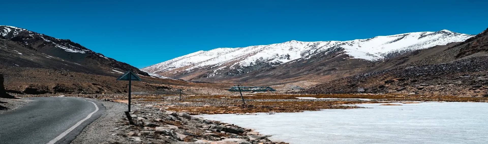
Kaza is the main hub for travelers exploring monasteries, high-altitude villages, and remote Himalayan roads. Kaza is the largest commercial town and the administrative headquarters of the remote Spiti Valley in the Lahaul and Spiti district of Himachal Pradesh, India. Situated at a high altitude of roughly 3,650 metres (11,980 feet) above sea level along the Spiti River, it functions as the central hub and base camp for travellers exploring this high-altitude cold desert. The town features a distinct landscape and Tibetan Buddhist culture closely resembling neighbouring Ladakh and Tibet. This Kaza travel guide covers everything you need to know before planning your Spiti Valley packages, including routes, weather, nearby attractions, and practical travel tips.Why Kaza is the Heart of Spiti ValleyKaza is the main town where travelers rest, refuel, acclimatize, and prepare for the tougher parts of the journey. Almost every road trip through the Kaza valley passes through this town. You will find the region’s main fuel station, cafés, ATMs, bike repair shops, hotels, and local markets here. That becomes important because many nearby villages have limited facilities and weak connectivity.Kaza is also divided into two parts, Old Kaza and New Kaza. Old Kaza feels quieter and more traditional, while New Kaza has cafés, homestays, and small restaurants filled with travelers discussing road conditions and altitude headaches over hot tea.How to Reach Kaza from Manali and ShimlaRoute to Kaza via ManaliThe Manali to Kaza route is shorter but far more challenging. The distance is around 180 kilometers, but the journey usually takes 8 to 10 hours because road conditions change constantly. After crossing the Atal Tunnel, the roads become rough in several patches, especially near Gramphu, Batal, and Kunzum Pass.The route generally opens between June and October. Heavy snowfall shuts this road during winter.Travel options include:HRTC buses from Manali to Kaza, ₹600–₹900 approximatelyShared cabs, ₹1,500–₹2,500 per seatPrivate taxis, ₹10,000–₹15,000 depending on seasonSelf-driving cars and bikes (₹1,500 - 2,200)Many riders prefer a Spiti bike trip style adventure through this route because the terrain feels wild and unpredictable. Water crossings become stronger in the afternoons, so starting early from Manali is always safer.Route to Kaza via ShimlaThe Shimla route is longer but safer and smoother. The total distance from Shimla to Kaza is around 400 kilometers, usually covered in 2 days with stops at Kalpa, Nako, or Tabo.This route remains open almost throughout the year unless landslides block certain sections temporarily. The gradual climb also reduces the risk of Acute Mountain Sickness, which becomes a serious issue for some travelers entering directly from Manali.Transport options:HRTC buses from Shimla to Kaza, ₹900–₹1,300Shared taxis from Reckong Peo and NakoPrivate cabs, ₹18,000 onwards for full tripRoad conditions stay comparatively stable because the route follows the Hindustan-Tibet Highway for a large stretch.If this is your first high-altitude Himalayan road trip, the Shimla side is usually the smarter choice in this Kaza travel guide.Manali vs Shimla RouteManali route: shorter, adventurous, rougherShimla route: safer, gradual altitude gain, better for familiesBike riders usually prefer ManaliFirst-time Spiti travelers often prefer ShimlaBest Time to Visit KazaJune to September is the best time to visit Kaza. Roads remain accessible, the weather stays manageable, and most tourist attractions operate normally during these months. Day temperatures usually range between 15°C and 20°C.October brings colder nights and fewer tourists, which many photographers prefer. Winter, from November to March, turns Kaza into a snow-covered cold desert. Temperatures can fall below -20°C, and the Manali route stays closed. Winter suits experienced travelers looking for snow landscapes and isolation, not casual tourists. If you are visiting for road trips, sightseeing, and village exploration, summer remains the most practical season.Key Places to Visit in KazaKey MonasteryKey Monastery, or Kye Gompa, is the largest and oldest Tibetan Buddhist monastery in Spiti Valley, Himachal Pradesh. Perched on a 4,166-meter (13,668 ft) conical hill, this 11th-century fortress-style complex serves as a major religious training center for lamas and houses ancient murals, rare manuscripts, and a 14-meter Maitreya Buddha statue. Inside, you will find prayer halls, ancient murals, and rooms filled with old manuscripts. Morning prayers create a completely different atmosphere here. Most travelers visiting the Kaza valley stop here early in the morning for better weather and fewer crowds.Chicham BridgeChicham Bridge is one of the highest suspension bridges in Asia, hanging roughly 13,000 feet above sea level. The bridge connects Chicham Village with Kibber and dramatically cuts travel time between the two areas. Standing in the middle of the bridge feels intimidating because of the deep gorge below. Strong winds are common here, especially in the evenings, so plan in or before the afternoon. The road leading to the bridge is narrow but offers some of the sharpest mountain views around Kaza.Kibber VillageKibber Village is a high-altitude settlement in the Spiti Valley of Himachal Pradesh, India, renowned for its striking Tibetan architecture, dramatic barren landscapes, and its status as one of the highest inhabited villages connected by a motorable road. Perched at an elevation of 4,270 metres (14,010 feet) on a limestone plateau, this remote village serves as a major hub for high-altitude trekking, stargazing, and wildlife photography. It houses a tight-knit community of around 366 residents living in uniformly built stone houses, maintaining an old-world charm where traditional Tibetan Buddhist culture still thrives.Buddha Statue in KazaThe iconic Buddha statue near Kaza is located in Langza Village, about 16 km (a 30-45 minute drive) from Kaza in Spiti Valley, Himachal Pradesh. This majestic 35-foot, brightly colored statue sits atop a hill at 14,500 feet, overlooking the valley, and is believed to guard the local villagers from harsh weather and evil spirits. Travelers stop here while covering Langza, Hikkim, and Komic together. The views during sunset look particularly dramatic because the mountains turn golden for a brief period. The road to the statue is steep in certain sections, so careful driving is important.Kaza MarketKaza Market acts as the town’s social center. You will find cafés, local woolen shops, bike rental stores, bakeries, and small restaurants serving Tibetan and North Indian food. Travelers usually gather here in the evenings after long drives around Spiti. The market is also one of the few places where mobile connectivity and ATM access work somewhat reliably. If you forgot medicines, gloves, or cash, this is your best place to sort things out before heading deeper into Spiti.The Spiti Trio: Hikkim, Komic, LangzaHikkim, Komic, and Langza, together, these three villages create one of the most popular day circuits near Kaza.Hikkim Hikkim is famous for having one of the world’s highest post offices. Travelers often send postcards from here because the postmark itself becomes a souvenir. The road to Hikkim is steep and dusty, but the surrounding mountain views make the drive memorable.KomicKomic is known as one of the world’s highest motorable villages. At over 4,500 meters, the oxygen level drops noticeably here. The village has a small monastery and offers a raw, isolated Himalayan experience that many tourists are not prepared for mentally or physically.Langza Langza is the fossil village of Spiti with a giant Buddha statue and peaceful homestays. Locals still find marine fossils here because this region was once underwater millions of years ago. The village feels calmer than Kaza and gives a more traditional Spitian atmosphere.Kaza: The Gateway to ChandratalApart from these attractions, Kaza is the main getaway to Chandratal, and most travelers heading toward Chandratal Lake use Kaza as their final major stop before entering rougher terrain. The distance from Kaza to Chandratal is around 110 kilometers, but the drive can easily take 5 to 6 hours because of broken roads and water crossings near Batal. Chandratal remains accessible mainly between June and October. Camping near the lake has strict restrictions now, so most camps stay a few kilometers away from the lake itself. Carry enough cash, fuel, and warm clothing before leaving Kaza because facilities become extremely limited after Losar.

Read More

Chasing Snowfall In Spiti Valley: When It Hits, Which Roads Close & Should You Go?
May 23, 20265 Minutes
Chasing Snowfall In Spiti Valley: When It Hits, Which Roads Close & Should You Go?
Snow is a white crystal of ice. When you heat it, it turns into water. The same water that you see in lakes looks beautiful. If you reduce the temperature, it changes the form to convert into snow. The Spiti Valley snow does the same. It covers the roads, houses, lakes, and rivers. But there is a catch. The same snow that makes it beautiful also makes it dangerous, isolated, and sometimes completely unreachable. So before you pack your bags and book Spiti Valley Packages for a "snow trip," read this first.When is the Best Time to Visit Spiti Valley for Snowfall?If seeing snow is your only goal, December to February is the window. But know what you are signing up for.Temperatures during this period drop to minus 20 degrees Celsius or lower at night. The best time to visit Spiti Valley for snow is actually November to early December, when fresh snow is falling, but the roads have not fully closed yet. You get the white landscape, the frozen rivers, and the clear skies without being completely cut off.April and May are a sweet spot for a different reason. The snow is still very visible on the mountains, the valley looks stunning, and the roads are much safer. If you do not need to be there during an active snowfall, this period gives you the visual experience without the risk of getting stranded.Here is a quick month-by-month read:October to November: Snow starts falling. Roads begin closing. Go early in this window if you want both accessibility and snow.December to February: Peak snowfall. Extreme cold. Only for experienced travelers who know what they are getting into.March to April: Snow is everywhere, but roads start reopening slowly. The Chadar-like frozen streams are worth seeing.May to June: Snow only in peaks, green in valleys, best accessibility.How many highways run through the Spiti Valley during the Snowfall?There are mainly two highways that connect Spiti Valley to the rest of India, and both behave very differently when Spiti Valley is hit by snow in the winter.1. NH 505, the Kaza-Manali HighwayThis is the route through Rohtang Pass and Kunzum Pass. It is only open from around June to October. The moment snow starts falling heavily, this highway closes. And it does not reopen until the next summer. So if you are planning to enter or exit via Manali, your window is limited.2. NH 5, the Hindustan-Tibet HighwayThis connects Shimla to Spiti through Kinnaur. It stays open for most of the year, though road conditions get challenging in deep winter. Landslide-prone zones near the Sutlej gorge can cause temporary blocks, but it is your only lifeline once the Manali route shuts down.Snowfall Blocks Roads: So Which Route Do You Actually Take?Two main routes, and the Spiti snowfall season decides which one you can actually use.1. The Shimla-Kinnaur Route (The All-Weather Route)This is the route that keeps Spiti connected to the outside world in winter. It runs through Delhi or Chandigarh to Shimla, then Narkanda, Rampur, Sarahan, Sangla, and Chitkul, Kalpa, Nako, Tabo, and finally Kaza.It is longer and more winding, but it does not shut down in winter the way the Manali route does. Road quality can be rough. Especially near the Kinnaur gorge sections. But travelers who have done it say the views of the Sutlej river canyon alone are worth the extra hours.2. The Manali Route (The Adventure Gateway)The path goes from Delhi or Chandigarh to Manali, through the Atal Tunnel, then Gramphoo, Batal, Kunzum Pass, Losar, and Kaza.Available only from June to October. Kunzum Pass sits at around 4,590 metres, and once snow blocks it, that is it. The road closes and does not open again for months. Seeing Spiti Valley in snow sounds romantic until you realise your only exit is buried under two feet of ice. If you are chasing the adventure of biking or driving this route, plan your dates carefully. Many travelers have gotten stuck here by ignoring weather forecasts.

Read More

Ladakh in May vs June vs July – Which Month Is Actually Best?
May 19, 20265 Minutes
Ladakh in May vs June vs July – Which Month Is Actually Best?
"I have been in Ladakh in May, in June, and in July. I personally experienced it was amazing. The weather was cold, yet it was summer season. The air was pollution-free. If I can bring it, I will keep it in my pocket and bring it to my city." - Neelam SharmaIt feels awesome, right? Yes, that's why Ladakh is very famous as a travel destination. People come here all over the month. Even when roads are closed due to heavy snowfall. They come here by flight and enjoy the fresh and cold snowfall. But May, June, and July have a different aura. Roads are without snow, the sky without clouds, and the temperature that gives you relaxation. But you are going for the snow! Don't worry, you can still see snowfall at very high altitudes like Khardung La and Chang La. So if you are planning a Leh Ladakh package from Delhi or anywhere in India. Read this before you book anything. The blog will clear all your doubts, How Is Ladakh in May?May is Ladakh waking up. Literally. After months of snow and silence, the roads start reopening, the guesthouses dust off their rooms, and the first batch of travelers arrive.Temperature in MayMorning (6 AM to 9 AM): 2°C to 5°C. Carry a heavy jacket. It bites.Afternoon (12 PM to 4 PM): 12°C to 20°C. Comfortable, almost warm in the sun.Evening (after 6 PM): 3°C to -5°C. Drops fast. Do not skip your layers.Weather in MayMostly clear skies and dry air. Snow is still sitting on the mountain peaks, which makes the views stunning. Occasional dusty winds pass through Leh, but rain is rare. Overall, May gives you clean weather days with crisp Himalayan light.How Are the Roads in May?The Manali-Leh Highway usually reopens in early to mid-May, sometimes the last week of April if snowfall has been light that year. The Srinagar-Leh Highway opens slightly earlier, around the end. Khardung La and Chang La passes open for vehicles in May, though they can still have icy patches in early May mornings.Road trips are actually a big draw in May. People coming from Delhi choose the Manali-Leh route as it is just opening, meaning fresh roads with almost no traffic. No jam at Rohtang. No convoy. Just you, your bike or SUV, and the mountains. This is exactly what makes Ladakh in May such a thrilling experience for road trip lovers.How Is the Crowd in May?Low to moderate. May is before the school summer vacation season, so families are still waiting. Most visitors in May are solo travelers, couples, and early-bird bikers. Hotels are available without pre-booking stress. Prices are lower. You get Ladakh more or less to yourself.If crowd-free is your priority, May is your answer.How Is Ladakh in June?June is when Ladakh shifts gears. Hard.Temperature in JuneMorning (6 AM to 9 AM): 7°C to 10°C. Noticeably warmer than May mornings.Afternoon (12 PM to 4 PM): 20°C to 25°C. Comfortable T-shirt weather in Leh town.Evening (after 6 PM): 8°C to 12°C. Still cool, still layering needed.Weather in JuneJune is stable and mostly sunny. It is probably the most photogenic month for Ladakh because the snow has not fully melted yet, the rivers are full from the melt, and the sky stays blue most of the time. Pangong Tso shows that famous turquoise blue shade in June because the ice has cleared.How Are the Roads in June?Both the Manali-Leh and Srinagar-Leh Highways are fully open and in good condition in June. Khardung La, Baralacha La, and Chang La are all accessible. Road-trippers can take either route without worrying about closures. Internal roads to Nubra Valley, Turtuk, and Hanle are also accessible.June: Is It the Most Crowded Month in Ladakh?Yes. And the reason is simple: school summer vacations begin in most Indian states by late May or the first week of June. Families who were waiting come in now. Add to that long weekend rush, corporate group tours, and a wave of bikers who plan their Manali-Leh ride every June, and you get the peak crowd situation in Ladakh in June.Hotels in Leh see 80 to 100 percent occupancy in June. Pre-booking is not optional; it is survival. Pangong Lake campsites fill up fast. Even taxis need booking.But, and this is important, the crowd in Ladakh never feels like a Goa beach crowd. The landscape is so vast that you rarely feel suffocated. You might wait 20 minutes extra at Khardung La for a photo, but the drive there will still feel empty.How Is Ladakh in July?July is for the bold ones. The riders, the adventure seekers, the people who do not mind a little unpredictability.Temperature in JulyMorning (6 AM to 9 AM): 10°C to 13°C. Noticeably warmer, especially in the valley.Afternoon (12 PM to 4 PM): 22°C to 27°C. This is almost warm by Ladakh standards.Evening (after 6 PM): 12°C to 15°C. Still cool, but lighter layers work.Weather in JulyMostly dry. But July brings what locals call "Ladakhi summer rain," which are short, sudden showers that come and go in an hour. Not the kind of monsoon that drenches you all day. Ladakh sits in a rain shadow zone, so the main Indian monsoon mostly skips it.Is July a Rainy Month?No, not in the traditional sense. Ladakh receives very little rainfall annually, around 100 mm per year, because the Himalayas block most of the monsoon moisture. Ladakh in July can bring brief afternoon showers and sometimes cause minor landslides on mountain roads, particularly near the Zoji La pass on the Srinagar-Leh route. But it does not rain continuously. Most days are dry and bright.The bigger concern in July is road blockages due to flash floods or landslides on specific sections, particularly around Sarchu on the Manali-Leh route. Check current road conditions before heading out.How Is the Crowd in July?Still high, but slightly less than June. The first week of summer vacation rush has settled. However, bikers peak in July because the road conditions are the most reliable and the weather is the warmest. Royal Enfield groups, cross-country riders, and adventure tourists make July feel energetic on the roads.Is Ladakh Affordable? A Month-by-Month Cost BreakdownMay:Flights (round trip from major metros): ₹10,000 to ₹18,000 per person. Off-season pricing is visible here.Stay: ₹800 to ₹2,500 per night for a decent guesthouse. Premium hotels start at ₹3,500.Transport (cab for sightseeing): ₹2,500 to ₹3,500 per day for a Leh-based SUV.Accessibility: All major roads are open; some remote roads may still have early-season restrictions.June:Flights (round trip): ₹14,000 to ₹28,000 per person. Prices spike during long weekends.Stay: ₹1,500 to ₹4,000 per night. Budget options book out fast without booking.Transport: ₹3,000 to ₹5,000 per day. Shared cabs and mini-buses are available for popular routes.Accessibility: Maximum. All passes, valleys, and highways are open.July:Flights (round trip): ₹12,000 to ₹22,000 per person. Slightly more relaxed than the June peak.Stay: ₹1,200 to ₹3,500 per night. Availability is better than June; negotiation is possible.Transport: ₹2,800 to ₹4,500 per day. Similar to June, but slightly easier to find availability.Accessibility: Roads are open, but monitor road conditions for landslide-prone sections.The most affordable month is May. Flights cost less, hotels have more rooms available, and you are not competing with school-holiday crowds for everything. If your budget is the deciding factor, May wins outright.If you are planning to visit Ladakh, then Read These best Places to visit in Ladakh & Things to do in Ladakh.

Read More

Winter in Meghalaya: What to Expect Before You Go
May 19, 202615 Minutes
Winter in Meghalaya: What to Expect Before You Go
Meghalaya in winter is not what most people picture. No snowfall, no frozen lakes, no ski resorts. But what you do get is fog so thick you cannot see ten feet ahead, waterfalls at their calm best, and a chill that catches you completely off guard, especially if you are coming from the plains. People from Delhi, Kolkata, or any part of India often land in Shillong thinking it will be a light jacket situation. It is not.So here is an honest look at what Meghalaya actually feels like, what to do, what to eat, and what to pack. If you have more doubts, then you can explore Meghalaya tour packages. It will give you the exact idea of what places should be in your itinerary. How is the Weather And Temperature in Winter?Meghalaya in winter stays cool and misty, with temperatures ranging from 4°C to 15°C in December and January. Mornings are cold, afternoons slightly warmer, and nights drop sharply. Rainfall is rare, but fog is constant. It is the kind of cold that sneaks up on you.Weather and Temperature by MonthDecember is the coldest stretch. Shillong, sitting at about 1,500 metres above sea level, drops to around 4°C to 6°C at night. During the day, it goes up to maybe 14°C or 15°C. But do not count on sunshine for long. Fog rolls in fast.January is similar. Roads to Cherrapunji or Mawsynram get misty, and the viewpoints at Nohkalikai Falls look dramatic, wrapped in clouds. Some travelers love this. Others find it frustrating because visibility is low.February starts getting gentler. Temperatures inch upward, mornings get less harsh, and the landscape starts looking fresher. This is honestly the sweet spot of Meghalaya winter travel.The eastern districts, like Tura or parts of Garo Hills, stay slightly warmer than Shillong, so if the cold is a concern, factor that in.What are the Festivals Celebrated in Winter?Winter in Meghalaya is not just cold weather and misty hills. There is real cultural life happening, and missing the festivals means missing half the point of visiting.Wangala Festival (if you time it right)Wangala is the harvest festival of the Garo tribe. It typically falls in November, but celebrations often stretch into early December in some villages. Drums, traditional dance, and community feasting are the highlights. It is one of the most visually rich cultural events in Northeast India.Christmas in ShillongMeghalaya has one of the highest Christian populations in India, around 74.59%, according to the 2011 Census. So Christmas here is genuinely celebrated, not just decorative. Shillong's Police Bazaar lights up, churches hold midnight mass, and the air actually feels festive. If you are visiting in late December, this alone is worth planning around. The Cathedral of Mary Help of Christians near Laitumkhrah is a good place to experience the celebration up close.New Year in ShillongThe city hosts live music events, street food gatherings, and small cultural programs around New Year's Eve. It is not Times Square, but it has its own local charm that does not feel manufactured.Shillong Winter FestivalThis is a newer addition, usually held in December. It combines music, food stalls, local crafts, and cultural performances. The venue tends to be open-ground spaces near the city center. Dates shift year to year, so check the Meghalaya Tourism website before you book.Is Winter Suitable for Camping, Trekking, and Hiking?Short answer: yes. But you need to know what you are getting into.Camping in winter in Meghalaya means cold nights, sometimes touching 3°C to 5°C near Cherrapunji or the living root bridge trails. A good sleeping bag rated for sub-zero temperatures is not optional; it is necessary. The good news is that leeches, which are a real problem during monsoon treks, are completely absent in winter. That alone makes many experienced trekkers prefer this season.1. David Scott TrailDavid Scott Trail is one of the most popular treks in Meghalaya, around 16 km long, connecting Mawphlang to Ladmawphlang. In winter, the trail is dry, clear, and manageable. The landscape looks stark but beautiful. Trek time is roughly 5 to 6 hours. Carry warm layers because the wind picks up in exposed sections.2. Living Root Bridge Trails (Nongriat)The double-decker living root bridge near Nongriat involves a descent of about 3,500 steps. Winter makes the stone steps less slippery compared to the monsoon, so footing is better. The trail still takes 3 to 4 hours one way. Start early, and carry a windproof jacket for the lower valley sections where cold air pools.3. Laitlum CanyonsLaitlum Canyons is not a strenuous trek, more of a scenic walk. But in winter, the canyon fills with fog in the morning hours, creating a view that looks almost unreal. Many visitors just sit at the edge and stare. That counts as a trek here.Camping near Cherrapunji or Sohra is possible through organized operators. Expect to pay around ₹1,500 to ₹3,500 per night for a proper camping setup with meals, depending on the operator and facilities.Any Seasonal Fruit Can You Try?Winter in Meghalaya brings a short but good window for local produce. Mandarin oranges, grown extensively in the Ri Bhoi district, are at their juicy peak in December and January. You will find them at roadside stalls for around ₹40 to ₹80 per dozen. Also look for local plums and wild berries sold by village vendors near Cherrapunji.Winter in Meghalaya turns the hills into a misty paradise, making it the perfect season to explore the best Places to Visit in Meghalaya like Shillong, Cherrapunji, and Dawki while enjoying exciting Things to do in Meghalaya such as camping, waterfall sightseeing, boating, and cave exploration.

Read More

10 Reasons to Visit Meghalaya at Least Once in Your Life
May 19, 202616 Minutes
10 Reasons to Visit Meghalaya at Least Once in Your Life
There are trips you enjoy, and then there are places that stay in your head long after you return home. Meghalaya belongs in the second category. Meghalaya is not just another Northeast state; it’s raw, it's untouched. Let’s say you are willing to visit Meghalaya in the coming time, but still confused about whether it will be worth it.After exploring Meghalaya closely and understanding how travelers actually experience Meghalaya tour packages, one thing is true: this is not a place you visit only for sightseeing. You come here for experiences you genuinely cannot recreate anywhere else in India. This blog mentions 10 big reasons to visit Meghalaya, so when you visit, you know exactly what to do, where to go, and how to make the most of your trip.10 Big Reasons to Visit Meghalaya1. The Beauty of Seven Sister FallsStanding in front of Seven Sister Falls is an unreal experience during the monsoon season. It is the union of seven waterfalls where seven separate streams crash down a massive cliff at the same time, creating one of the most beautiful sights in Northeast India.Falling from nearly 1,000 feet, this waterfall is one of the tallest in India. Its huge drop and beautiful surroundings make it a place you should not miss during your Meghalaya trip.The waterfall gets its name from the seven northeastern states it symbolically represents. Mist covers the valley, clouds drift across the cliffs, and the roar of water echoes through Sohra. Sunset views here are especially stunning when the golden light hits the falls after heavy rain.2. Visit Asia’s Cleanest Village, MawlynnongWelcome to the Cleanest Village of Asia, Mawlynnong. Most villages become tourist spots after getting famous. Mawlynnong managed to stay peaceful even after becoming widely known as Asia’s cleanest village. You will see bamboo dustbins lining the pathways, flowers blooming outside almost every house, and locals maintaining cleanliness with serious discipline. The villagers are very conscious about plastic use, rainwater harvesting, and community participation keeps the village spotless. The surprising part is that this cleanliness does not look forced. It feels natural to the way people live here, which is very rare to see. This discipline and cleanliness are what make Mawlynnong special.3. The Sacred Mawphlang ForestThe Mawphlang Sacred Forest is said to be sacred because it is believed that the forest is spiritually protected by a local deity, Labasa. The forest carries stories, beliefs, and traditions that locals have protected for centuries. Ancient trees, thick roots, moss-covered stones, and unusual silence make the forest feel mysterious from the moment you enter.Local beliefs say that Labasa does not allow anyone to take anything away from the forest, not even a flower or a small stone. People believe those who break this rule face serious consequences.Visitors are also warned not to remove even a leaf from the area. Unlike regular forests, where people mainly visit for photography, Mawphlang gives you a very unique reason to visit Meghalaya - a strange feeling of stepping into a place that nature still fully controls.4. Trek to the Living Root BridgesLocated in Nongriat, Doube Decker Living Root Bridges are unique because local tribes grow them naturally using tree roots instead of building with concrete or wood. These bridges become stronger with time and last for generations.Some are more than a hundred years old and still strong enough to handle daily use. The trek is nearly 3,000 stone steps through forests, streams, and small Khasi villages. It takes around 4 to 6 hours in total. And the moment you stand on those living roots surrounded by jungle sounds, the exhaustion disappears quickly.Make sure to wear comfortable shoes, and good stamina is important because the return climb can feel challenging.5. Float on the Crystal Clear Waters of DawkiThe Umngot River in Dawki became famous online for a reason. During winter, the water turns so transparent that boats appear to float in the air. You can clearly see stones resting deep below the river surface. Early morning is the best time because the water stays calm and reflections become sharper.Apart from boating, snorkeling, rafting, and fishing in the Dawki River are some top reasons to visit Meghalaya. What makes the experience memorable is not only the clarity but also the peaceful atmosphere around the river. No loud crowds, no massive commercial setup, only clean water, hills, and silence.6. The Music Culture of ShillongShillong is considered the “Rock Music Capital of India.” It has a music culture that surprises everyone. Small cafés, roadside bars, and local venues regularly host live performances, and many talented musicians here grow up listening to rock, blues, and western music from an early age.The recently famed Rapper, Reble, is one of the greatest examples of how Shillong treats music. She gave many songs in recent times that got millions of views. It is because music is deeply connected to the local lifestyle rather than being treated as occasional entertainment.Places to visit in Meghalaya will surely start with Shillong, because Meghalaya is one of the most famous hill stations in India. It must be visited not just because of its music culture, but also because of its wonderful attractions like Elephant Falls, Laitlum Canyon, and Umiam Lake.7. Witness Meghalaya’s Matrilineal CultureMany travelers do not realize Meghalaya follows one of the few surviving matrilineal systems in the world. In Khasi and Garo communities, property often passes to daughters, especially the youngest daughter of the family. Women play a central role in family structure and household inheritance.For visitors coming from other parts of India, this cultural difference becomes one of the most fascinating reasons to visit Meghalaya. It changes how you observe local traditions, markets, and daily life.You can experience Meghalaya’s matrilineal culture mainly in the Khasi and Garo communities, especially in places like Shillong, Mawlynnong, and villages around Cherrapunji.8. Trek to the Laitlum CanyonLocated 22 Km from Shillong, Laitlum Canyon is the kind of place where people stop talking for a few minutes after reaching the viewpoint. Endless green valleys stretch far into the distance, clouds drift through the cliffs, and tiny village trails disappear into the hills below.The trek itself is not extremely technical, but the steep descent can feel challenging. The trek is 2 to 4 kilometers, depending on the route you take. The trail includes steep steps, narrow paths, and beautiful valley views. Most travelers complete the trek in 1.5 to 3 hours while stopping for photos and short breaks.9. Explore the Wettest Place in the World, MawsynramYes, Meghalaya is popular as a monsoon destination, but this rain has made Mawsynram a popular tourist attraction. Rain is not just weather in Mawsynram; it shapes daily life.This small village in the East Khasi Hills of Meghalaya receives some of the highest annual rainfall on Earth. Houses are designed to handle constant downpours, waterfalls appear almost everywhere during the monsoon, and clouds often cover entire roads within minutes.Visiting Mawsynram during heavy rain feels dramatic and chaotic in the best possible way. Even the sound of nonstop rainfall becomes part of the experience, making it one of the biggest reasons to visit Meghalaya at least once in your lifetime.10. Experience Meghalaya’s Cave ExplorationMeghalaya hides some of the most fascinating cave systems in India. Places like Mawsmai Cave attract travelers who want more than regular sightseeing. Inside, narrow passages, limestone formations, natural chambers, and dripping cave walls create a completely different environment from the forests outside.Popular caves in Meghalaya are Mawsmai Cave, Arwah Cave, and Krem Puri. Some caves are easy for beginners, while others require serious exploration skills. The excitement comes from the unpredictability because every turn inside the cave feels darker, quieter, and more mysterious than the last.Discover 10 Reasons to Visit Meghalaya with its breathtaking waterfalls, living root bridges, scenic hills, and vibrant culture, making it one of the best destinations for travelers seeking unforgettable Reasons to Visit Meghalaya, amazing Places to Visit in Meghalaya, and exciting Things to do in Meghalaya.

Read More

North Vietnam vs South Vietnam: Which One Should You Explore First?
May 13, 202611 Minutes
North Vietnam vs South Vietnam: Which One Should You Explore First?
Vietnam is split into three main regions – the North, the Center, and the South. Weather, climate, and culture differ depending on the area. Mainly, the problem lies in the fact that travelers lack the necessary information regarding the geographical aspect of the destination. Hence, their travels are not properly organized, resulting in failure. They decide on how to fly to Vietnam through Instagram videos, going to Hanoi or Ho Chi Minh City. In this case, the traveler spends about half of the time in confusion about what he/she might miss. North and South Vietnam seem to be two distinct worlds rather than two separate parts of the country. The one you are supposed to visit depends exclusively on your type of tourist. To escape from all the trouble and stress, purchase Vietnam tour packages to keep everything under control.Hence, here is a sincere answer. Let's start with North Vietnam vs South VietnamNorth Vietnam: Slower, Colder, and Incredibly RawNorth Vietnam is where you should go when you need to feel the country, not merely capture images of it.HanoiThere is something about Hanoi that sets it apart from any other Southeast Asian metropolis. The streets are narrower. The cuisine is more authentic. Witness the hustle and bustle surrounding Hoan Kiem Lake early in the morning; see old ladies practicing tai chi alongside young children biking to school.Halong BayWhile Halong Bay is a given, the limestone peaks protruding from the green water are genuinely mesmerizing. But honestly, when comparing travel experiences across North and South Vietnam, Ninh Binh quietly stands out even more. It gives you a calmer experience without huge tourist crowds and far less hassle. A two-day trip to Ninh Binh can cost anywhere between ₹3,000 to ₹6,000 per day, depending on your style, but the wooden rowboat ride through the caves of Trang An is something you genuinely remember later.SapaIn Sapa, you must witness the terraced rice paddies and the hilltribe villages. However, it would help if you kept in mind that visiting Sapa during its most touristy times (October, March) may ruin the atmosphere. Visit Sapa a bit off-peak and prepare yourself to be mesmerized.Climate reminder: North Vietnam will get chilly between December and February. Hanoi can get as low as 12 to 15 degrees centigrade. Bring warm clothing. No one ever tells you that in travel videos.South Vietnam: Louder, Faster, and Addictively FunIn between North Vietnam vs South Vietnam, South Vietnam also has many amazing cities and places. Let's explore them one by oneHo Chi Minh CityLife never sleeps in Ho Chi Minh City. Whether it be midnight or a Tuesday, the vibe here just keeps on going, and if you love cities with an edge, then you'll love living in Ho Chi Minh. The food alone is worth the flight. A bowl of hu tieu at a street stall in District 5 costs around ₹80 to ₹150 and is, without exaggeration, one of the best things you will eat in Southeast AsiaThe Mekong DeltaIt doesn't matter how far into the south of Vietnam you go, but you definitely won't regret a visit to the Mekong Delta region. This includes floating markets, village communities that rely solely on water travel, and fruit farms that span miles upon miles. Expect to pay somewhere between ₹2,500 and ₹4,500 for a day-long trip from Ho Chi Minh City to Can Tho (return).Da LatThere is no such thing as being too far away from the beach when you're in the south of Vietnam. Da Lat is a French colonial-era hill station set within pine forests and strawberry farms, and it is nothing like other places along the coast. Accommodation costs here will run you approximately ₹1,500 per night.The Con Dao islandsThe Con Dao Islands are a great getaway spot. Beaches are pristine, tourist numbers are relatively low, and there is even some eerie historic value in the colonial-era prison facilities.So Which One Do You Visit First?Still fighting over North Vietnam vs South Vietnam, which should visit first. Here is the practical answer.Visit the North First If you are coming from October to March. The weather in the north is moody but manageable, and Halong Bay, Ninh Binh, and Sapa are at their clearest. The south stays hot and humid year-round, so you can always save it for later.Visit the South FirstIf you are pressed for time or on a tighter budget. Getting around Ho Chi Minh City is cheaper and more efficient. Flights within India to Ho Chi Minh City (direct or one-stop via Bangkok or Singapore) often start around ₹18,000 to ₹28,000 return, depending on how early you book. Hanoi is slightly pricier to reach from most Indian cities.And if someone tells you to "do all of Vietnam in 7 days," smile politely and ignore them. You need at least 5 to 6 days per region to actually experience it rather than just transit through it.One More Thing Nobody Talks AboutThe divide between North and South Vietnam is not just geographical. Food, accents, attitudes toward time, even how people drink their coffee, everything shifts noticeably once you cross the middle. Central Vietnam (Hue, Da Nang, Hoi An) sits between them and deserves its own separate trip entirely.Start with one region. Do it properly. Then come back for the other. That is how you actually get Vietnam.If you’re confused between exploring North or South Vietnam first, the best approach is to choose based on the experiences you enjoy most nature, culture, nightlife, or beaches. You can also explore our recommended Places to Visit in Vietnam and must-try Things to Do in Vietnam to plan a memorable and well-balanced itinerary.

Read More

Vietnam Café Culture: Which Unique Coffee Experiences Should Tourists Not Miss?
May 13, 202612 Minutes
Vietnam Café Culture: Which Unique Coffee Experiences Should Tourists Not Miss?
When you land in Hanoi early in the morning. The streets are already loud. You can see motorbikes everywhere. Then you passed by a cafe, and the smell! That deep, smoky, almost chocolatey smell drifting out of a tiny shop where an old man sits on a plastic stool sipping from a glass the size of your fist. That is Vietnam famous coffee. And no, it is nothing like what you get at a mall cafe back home.The urge to drink the world's finest coffee can get you anywhere in the world. If you want to have the experience of it. You can add the cities in your Vietnam tour packages, where you can find the world's finest coffee. Is the Cultural History of Coffee in Vietnam Exciting?Yes, very much. As per history, coffee came to Vietnam through French colonists in the 1800s. But here is the part that makes it interesting. Vietnam did not just copy French cafe culture. It transformed it completely. Fresh milk was hard to get, so people started using sweetened condensed milk instead. The result? A richer, thicker, sweeter brew that became its own thing entirely.Vietnam is now the second-largest coffee producer in the world. Most of it is Robusta beans, which are stronger and more bitter than the Arabica variety you find in most Western cafes. That strength is exactly what gives Vietnam famous coffee its punch.But what really sets it apart is not the bean. It is the ritual. The slow drip filter, called a "phin," sits on top of your glass, dripping coffee drop by drop. You wait. You sit. You watch. Nobody is rushing you. That patience is part of the experience.Egg coffee, coconut coffee, salt coffee, yogurt coffee. These are not quirky tourist gimmicks. These are real drinks that locals have been making for decades. Each city is putting its own spin on the cup.Where Can You Get the Famous Vietnamese Coffee?If you want to do a coffee date with your loved ones, then these cities can be the best pick. The smell of fresh coffee follows you everywhere here.1. HanoiThis is where egg coffee was born. A man named Nguyen Van Giang invented it in the 1940s when milk was too expensive. He whipped egg yolk with sugar and coffee until it became thick and creamy, like a dessert you drink. Cafe Giang on Dinh Tien Hoang Street still serves it. Sitting in that old, narrow room, surrounded by locals who have been coming here for years, you feel like you have found a secret the rest of the world has not caught up to yet.2. Ho Chi Minh CityVietnam famous coffee culture here is more grab-and-go. You will find it on pavements, inside tiny alleys, and in converted French villas. Coconut coffee is the signature here. Cold, blended, and almost like an iced dessert, it is made with coconut milk or coconut cream mixed into strong black coffee. On a hot afternoon in Saigon, nothing hits the same.3. Da LatIt is Vietnam's highland city, sitting at around 1,500 meters above sea level. The cooler climate makes it ideal for growing Arabica beans, which are rarer in Vietnam. The cafes here feel different, too. Think mountain mist, pine trees, and cups that taste cleaner and more delicate. Da Lat is where Vietnamese coffee gets a little quieter, a little more thoughtful.4. Hoi AnBlends old-town charm with cafe culture beautifully. Many small coffee shops here are run by families, and they roast their own beans. You sit by the river, watch lanterns float by at night, and sip something that tastes like it was made just for that moment.What Makes Vietnamese Coffee Different from the Rest?The phin filter is the key piece. It is a simple four-part metal device, no electricity, no paper filter, no pressure. Just hot water and gravity doing the work slowly. Vietnam famous coffee that comes out is concentrated and intense. You can drink it hot, or pour it over ice for cà phê sữa đá, which is iced milk coffee. This is probably the most consumed drink in the country.Salt coffee is a Hue specialty. Yes, actual salt. A small pinch of salt is added to the cream or milk layer on top. It sounds strange. But salt cuts the bitterness and makes the sweetness feel more balanced. Try it once before you judge it.Yogurt coffee exists, too, mostly in Hanoi. Frozen yogurt at the bottom, strong black coffee poured on top. You mix it yourself. The sourness of yogurt against the bitterness of coffee sounds like a chemistry experiment. But tastes like something a pastry chef would charge a lot for back home.How Should You Actually Experience Coffee in Vietnam?If you want to taste real coffee in Vietnam, then don't go for the fancy chain cafes your hotel menu recommends. Go where the plastic stools are tiny, the glasses are small, and the bill is under ₹50. That is where the real stuff is. You can sit there and have the taste of divine coffee.Generally, most traditional Vietnamese coffee costs between ₹40 and ₹150, depending on the type and city. Egg coffee in a touristy spot might go up to ₹300. Still cheaper than a single shot at most Indian café chains.You should go in the morning. Vietnam famous coffee culture is heavily tied to mornings. Locals sit out on the pavement before 9 AM, newspaper or phone in hand, coffee on the ground beside them. Join that rhythm. Order without overthinking. Point if you have to.And slow down your pace. That is the whole point of the phin. It forces you to stop. You cannot rush it. While it drips, you just exist for a few minutes. In a country that moves so fast, that little pause is quietly radical.Vietnamese cafe culture is not an attraction you visit. It is something you settle into. One cup, one plastic stool, one slow morning at a time. The coffee scene in Vietnam offers much more than just great flavors, it gives travelers a glimpse into local culture, daily life, and hidden city corners. Along with trying these unique cafés, you can also explore popular Places to Visit in Vietnam and add exciting Things to Do in Vietnam to create a complete and unforgettable travel experience.

Read More

Sunsets in Vietnam: 5 Best Vietnam Sunset Spots
May 12, 202612 Minutes
Sunsets in Vietnam: 5 Best Vietnam Sunset Spots
Vietnam has no shortage of beautiful landscapes, and one of those beautiful places is where you can watch sunsets. Travelers plan their food stops and sightseeing carefully, but they often miss the real magic hour of the country. Some of the best travel memories in 2026 are being created at hidden evening viewpoints instead of famous tourist attractions. If you are planning through Vietnam tour packages, make sure sunset experiences are part of the itinerary because some of the best Vietnam sunset spots are still surprisingly underrated.What is the Time of Sunset in Vietnam?The sunset timing in Vietnam is around 5:30 - 6 PM. However, sunset timings in Vietnam slightly change depending on the region and season. In northern areas like Hanoi and Ha Long Bay, sunsets usually happen between 5:15 PM and 6:30 PM. Central regions like Da Nang see sunsets around 5:20 PM to 6:10 PM, while southern Vietnam often gets slightly longer evening light. Updated 2026 travel trends also show that weather haze during monsoon months can reduce visibility.Best Season for Sunsets in VietnamThe best months for sunsets in Vietnam are usually from October to April. During this period, skies remain clearer, humidity is lower, and sunset colors stay visible for longer. Summer sunsets can look dramatic too, especially after rainfall, but clouds may block the sun unexpectedly. One thing experienced travelers notice is that coastal sunsets after light rain often create pink and purple skies for barely 10 minutes before fading away. Many famous Vietnam sunset spots are getting busier in 2026, so arriving early matters more than ever.Top Unique Places to Watch Sunsets in Vietnam1. Ha Long Bay (Quang Ninh)Among all Vietnam sunset spots, this one feels the most cinematic. Watching the sunset in Ha Long Bay feels almost unreal because the sunlight reflects between giant limestone islands floating on calm water. The best experience usually comes from evening cruises rather than rushed day trips. If possible, choose viewpoints near Ti Top Island for wider evening views. Winds become surprisingly cold after sunset, even during warmer months, so carrying a light jacket helps. 2. My Khe Beach (Da Nang)My Khe Beach is a very different sunset mood. Instead of dramatic cliffs, you get soft golden reflections across a long shoreline with relaxed evening energy. Around sunset time, locals gather for volleyball, jogging, and beach walks, making the atmosphere feel even more enjoyable and authentic rather than overly touristy. The southern side of the beach is usually less crowded and better for peaceful sunset watching. Weekdays are far better than weekends if you want quieter moments.3. West Lake (Hanoi)Most travelers in Hanoi focus only on the Old Quarter, but West Lake gives one of the calmest city sunsets in Vietnam. Small lakeside cafés around Trinh Cong Son Street become perfect evening spots when the sunlight starts reflecting on the water. During winter, the mist around the lake creates a softer and more cinematic look. One thing to remember is that Hanoi traffic becomes heavy before sunset, so leaving early saves a lot of frustration.4. Thien Phuc Duc HillThien Phuc Duc Hill remains one of the lesser-known Vietnam sunset spots. Unlike crowded city locations, this hill is very peaceful. During colder months, clouds often move below the viewpoint, creating an almost floating effect during sunset. The trail can become slippery after rain, so proper shoes are important. 5. Mui Ne Sand DunesThe sand dunes near Mui Ne create sunset landscapes that many people do not expect from Vietnam. Red and white dunes glow beautifully during golden hour, making the area look almost desert-like. Jeep tours are common here, but the quieter experience comes from walking slightly away from the parking zones. Coastal winds become strong in the evening, and sand can easily blow into your eyes, so sunglasses are genuinely useful even during sunset hours.How to Plan for Sunsets in Vietnam?Reach the location at least 45 minutes before sunsetCarry a light jacket for beaches, lakes, or hill viewpointsKeep offline maps ready for remote areasAvoid weekends at famous sunset locationsCarry a power bank if you plan to do photographyCheck weather forecasts before leaving your hotelAccount for evening traffic, especially in Hanoi and Da NangMany travelers in 2026 are missing sunset timings simply because Vietnam’s evening traffic delays are more unpredictable than expected.Final RecommendationThe right sunset experience can completely change how a destination feels in your memory. Some places feel energetic, while others feel peaceful and personal. The best approach is to mix famous locations with lesser-known viewpoints during your trip. If you are planning a Vietnam holiday in 2026, Viacation can help you explore hidden experiences beyond regular itineraries. Peak travel dates fill quickly, so sending an early inquiry can help you to get the best deals without rushing later.Every sunset spot in Vietnam offers a different vibe, from peaceful coastal views to lively city evenings. To make the most of your vacation, explore our recommended Places to Visit in Vietnam and discover amazing Things to Do in Vietnam that can turn your trip into a truly unforgettable adventure.

Read More

North Bali vs South Bali 2026: Why Indians Keep Missing the Better Half of the Island
May 12, 202611 Minutes
North Bali vs South Bali 2026: Why Indians Keep Missing the Better Half of the Island
If you are a hardcore traveller, you must know that Bali has two sides, North and South. Most Indian travellers return from Bali thinking they’ve “seen Bali” after spending 5 days between Kuta, Seminyak, and Ubud. But Bali in 2026 is no longer just beach clubs, floating breakfasts, and traffic-filled sunset roads. The island is split into two very different experiences: North Bali and South Bali.And honestly, most tourists only experience the louder half.That’s also why travelers searching for Bali tour packages are now asking more questions before booking. They want to know where Bali actually feels peaceful, where the crowds are lower, and whether North Bali is worth the long drive. Viacation has seen this shift clearly in updated 2026 travel inquiries. And this is why this blog is very necessary.Experiences You Get in North and South Bali1. Beach Cafes & NightlifeIf your idea of a holiday is packed nightlife and social energy, South Bali wins easily. South Bali is designed for stimulation. The moment you enter Seminyak or Canggu, you notice it immediately: music from beach clubs, packed cafés, scooters everywhere, influencers taking photos at sunset, and restaurants open till midnight. For first-time Indian travelers, this side feels exciting because everything is accessible. With Indian food, shopping streets, clubs, and currency exchanges, it’s easy to travel.North Bali is almost opposite. Places like Lovina don’t try hard to entertain you. Cafés are smaller, roads are quieter, and evenings end earlier. Instead of beach DJs, you hear waves and scooters passing occasionally. Some travelers call it “boring.” Others call it the side of Bali they were actually looking for.2. Beaches: Famous Beaches vs Peaceful CoastlinesSouth Bali’s beaches are built around activity. Kuta is crowded almost every evening. Melasti Beach has become one of the biggest social media spots in Bali. Surf schools, beach clubs, ATV rides, café hopping, etc. For honeymooners and first-time international travelers, this works well because everything feels lively.But North Bali beaches are different in both appearance and mood. The sand is darker because of volcanic activity. The waves are calmer. You won’t find rows of luxury clubs on every shoreline. Instead, beaches here feel slower and more local.One of the biggest experiences is the sunrise dolphin tour in Lovina. But even that shows the difference between the two sides of Bali. South Bali sells sunsets and nightlife. North Bali wakes up before sunrise.And honestly, many Indian travelers are surprised by this. They expect all of Bali to look like Instagram reels from Seminyak. North Bali feels quieter, greener, and less commercialized.3. Waterfalls & NatureThis is where the gap becomes much bigger in 2026. South Bali waterfalls near Ubud are easier to reach, which is why most tourists visit them. But many of these places now feel heavily commercialized. You’ll often find queues for photos, ticket counters everywhere, and crowded viewing points.North Bali still gives a stronger feeling of discovery. Places like Sekumpul Waterfall and Munduk involve mountain roads, cooler weather, and longer drives through villages. The journey itself starts becoming part of the experience.Bottom of the line is: South Bali feels curated for tourism. North Bali still feels connected to local life.4. Travel Fatigue — The Biggest 2026 Reality CheckThis is probably the most important difference nobody explains properly before booking Bali. South Bali traffic has become exhausting in 2026. People plan 4 - 5 activities daily because locations “look nearby” online. Then half the day disappears in cars. Many travelers return saying Bali was beautiful but tiring.North Bali has the opposite problem. It’s far from the airport. Reaching there can take 3 - 4 hours, depending on traffic and weather. That distance scares many tourists away.But once you arrive, the pace changes completely. Roads are emptier. Drives are scenic instead of stressful. You spend less time calculating routes and more time actually experiencing places.Ironically, many travelers skip North Bali because of the drive, then later regret not staying there longer.5. Hotels & Stay ExperienceSouth Bali dominates when it comes to luxury resorts. Private pool villas, honeymoon properties, rooftop bars, beach resorts South Bali is better developed for premium tourism. If someone is visiting Bali for 4–5 days only, staying south makes logistical sense.Whereas North Bali hotels focus more on atmosphere. You’ll find jungle lodges, mountain-view villas, eco-resorts, and quiet oceanfront stays. These places often feel more personal because tourism is still lighter here compared to Seminyak or Kuta.Which Side of Bali Should Indians Choose in 2026?Choose South Bali if you want:NightlifeCafé cultureShoppingBeach clubsShorter travel distances between tourist attractionsChoose North Bali if you want:NaturePeaceful staysWaterfalls and mountain landscapesSlower travelA less commercial version of BaliBut the smartest Bali travelers in 2026 are no longer choosing only one side. They’re combining both. Spend a few days in the south for energy and convenience, then move north for the quieter and more scenic side of the island. That balance is where Bali starts feeling complete instead of rushed.If you’re planning a trip to Bali in 2026, Viacation can help you build a more balanced itinerary that covers both North and South Bali instead of the usual overcrowded tourist circuit.

Read More

Bali vs Thailand 2026: Where Should Indians Go This Year?
May 12, 202612 Minutes
Bali vs Thailand 2026: Where Should Indians Go This Year?
When you decide to visit anywhere. There are some questions that come to every mind. After lots of research and consideration. You're finally stuck between two countries, Bali or Thailand? Now you are under stress! Every Insta reel and snap showing both are stunning. But you don't have the budget for both. So, don't stress anymore, we're gonna give you the best detailed information about both destinations.Both are on every "best international trips for Indians" list. Both are affordable. Both are gorgeous. And yet, they are nothing alike. Picking the wrong one for your travel personality is like ordering biryani and getting pasta. Technically food. Not what you wanted. You can also explore Thailand or Bali tour packages for more itinerary options.So here is an honest assessment without sugar-coated language for 2026.Which is More Expensive, Bali or Thailand?Thailand is considered cheaper than Bali. A 5-night trip to Thailand averages around ₹35,000 to ₹55,000 per person, while Bali costs ₹45,000 to ₹70,000. The gap comes from flight connections and higher activity costs in Bali.Bali Cost Breakdown (Per Person, 5 Nights)Flights (round trip via Singapore or KL): ₹22,000 to ₹35,000Stay (3-star hotel): ₹2,500 to ₹4,500 per nightFood per day: ₹700 to ₹1,200Activities and transfers: ₹5,000 to ₹10,000Thailand Cost Breakdown (Per Person, 5 Nights)Flights (round trip): ₹16,000 to ₹28,000Stay (3-star hotel): ₹1,800 to ₹3,500 per nightFood per day: ₹400 to ₹800 (street food is incredibly cheap)Activities and transfers: ₹4,000 to ₹8,000Thailand is more affordable overall, mainly because flights are cheaper and street food in Bangkok costs as little as ₹80 to ₹150 per meal. But here is one thing people miss: Bali's private pool villas go for ₹4,000 to ₹6,000 per night. If you are travelling as a couple or in a group and want that luxury-on-a-budget feel, Bali actually punches above its weight on accommodation value.Which Country Has an Easier Visa Process?The visa process for Bali or Thailand is easy. But they work differently.1. Thailand Visa for IndiansThailand gives Indians 60 days of visa-free entry. No fees, no paperwork before you travel. You walk in, show your passport, return ticket, and hotel booking. Done in 15 minutes. Just make sure your passport has at least 6 months of validity.2. Bali (Indonesia) Visa for IndiansBali uses a Visa on Arrival system. You pay roughly ₹2,900 at the airport counter before immigration. It gives you 30 days, which you can extend for another 30 days if you want to stay longer. Indonesia now technically requires proof of funds at around $100 per day, so carry a bank statement or a credit card with a reasonable limit, just in case.Both are first-timer-friendly. No embassy visits, no stress. Thailand wins on cost since it is completely free. Bali wins if you want the option to extend your stay without leaving the country.Are Both Destinations Veg-Friendly?Bali: Much easier for vegetarians. Bali is a Hindu island, and that changes everything. Ubud has entire streets of plant-based cafes, raw food restaurants, and Indian eateries. You will find dal, paneer, and thali-style meals in Seminyak without even looking hard. Tempeh and tofu are staples in local warungs. Even the non-vegetarian Balinese food is relatively light on meat.Thailand: Trickier, but manageable. Fish sauce and oyster sauce sneak into almost everything, including dishes that look completely vegetarian. The safest trick is to ask for "jay" food, which is Buddhist vegan, available at dedicated restaurants across Bangkok, Chiang Mai, and Phuket. Indian restaurants are easy to find near tourist areas. But if you are a strict vegetarian or Jain, you will need to stay alert.Verdict: Bali is clearly more veg-friendly for Indian travellers.Beach Fight: Whose Beaches Are More Stunning?Phuket alone has over 30 beaches. Phi Phi Island looks like a screensaver. Railay is surrounded by dramatic limestone cliffs with no road access. Koh Samui, Koh Phangan, and Krabi each one feels like a different universe. The water in the Andaman Sea is genuinely turquoise, the kind of colour you think is only real in edited photos.Bali's beaches are honestly a mixed bag. Kuta is crowded and not particularly attractive. Seminyak has a great sunset bar scene, but the beach itself is ordinary. To get truly beautiful beaches in Bali, you have to take boats to Nusa Penida or Nusa Lembongan, which adds both cost and logistics.Where Bali fights back: surf culture. Uluwatu and Canggu have world-class breaks. If learning to surf is on your bucket list, Bali beats Thailand easily.For pure beach beauty, Thailand wins this round.Are Both Suitable for Every Type of Traveller?First-time international traveller: Thailand. It is cheaper, more straightforward, and easier to navigate. Bangkok has English signage everywhere. Getting from the airport to your hotel takes 30 minutes on an express train.Family with kids: Thailand edges ahead. More kid-friendly activities, simpler food options, and better public transport mean less parental stress.Solo female traveller: Both are safe. Thailand has more backpacker hostels and social infrastructure if you want to meet people. Bali is calmer and more introspective, better if you want peace over parties.Honeymooners: Bali, without question. Private pool villas, temple sunsets, rice terrace walks, the whole vibe is built for romance. Thailand is fun, but it does not feel intimate in the same way.Friend groups: Thailand. Nightlife, island hopping, beach parties, zip lines in Chiang Mai jungles. The energy matches a group looking to have a lot of fun without overthinking it.So, Who Wins, Bali or Thailand?In the competition between Bali vs Thailand, who wins? It depends on what you are chasing.You can go to Thailand if this is your first international trip, and you want to stretch your budget. You love beaches and variety, or your group wants nightlife and adventure. Or go to Bali if you want a slow, spiritual experience. If vegetarian food is important to you, you are on a honeymoon or a couple's trip.And if you still cannot decide? Most people who visit one end up visiting the other within two years. They scratch completely different itches. Thailand gives you the kind of holiday where every day is packed, loud and fun. Bali gives you the kind where you come back feeling like you actually rested. Both are worth your time. Pick based on where your head is right now, not where someone else thinks you should go.

Read More

Camping in Meghalaya: Best Spots for Nature Lovers
May 12, 202615 Minutes
Camping in Meghalaya: Best Spots for Nature Lovers
There are hill stations, and then there is Meghalaya. It's a place where clouds float beside your tent, rivers look unreal, and silence actually feels peaceful. Camping in Meghalaya is something that lets you disconnect from the constant city noise. With more travelers now looking for raw nature experiences in 2026, this destination is quickly becoming a favorite among backpackers and couples for camping. Many travelers are also choosing Meghalaya tour packages through Viacation to explore these remote camping locations comfortably.What are the Reasons to Go Camping in Meghalaya1. Nature Feels Closer HereUnlike commercial hill stations, Meghalaya’s camps are surrounded by rivers, forests, waterfalls, and peaceful mountain landscapes.2. Pleasant Weather for Outdoor StaysThe cool climate makes camping enjoyable almost throughout the year, especially during winter and post-monsoon months.3. Incredible Stargazing ExperiencesFar from city lights, many camping sites in Meghalaya offer crystal-clear night skies that feel completely different from urban life.4. Local Khasi Culture Adds More DepthSeveral camps include local meals, bonfires, folk stories, and interactions with nearby village communities.What is the Best Time for Camping in MeghalayaThe best time for camping in Meghalaya is between October and April because during this time, the weather stays cool, the skies remain clearer, and the road conditions are better. While monsoon camping sounds exciting on social media, heavy rainfall can create travel delays and slippery terrain. Winter mornings in 2026 are becoming especially popular among photographers but keep in mind that winter nights and extremely cold when it comes to sleeping inside a camp. One practical thing most first-time travelers forget is carrying waterproof shoes and warm layers, as nights can become surprisingly cold even during summer.Best Camping Sites in Meghalaya1. Dawki Riverside CampingDawki is easily one of the most wonderful camping sites in Northeast India. The crystal-clear Umngot River looks almost invisible during the winter months, making boats appear like they are floating in the air. Nights near the river can become extremely cold, so carrying thermal wear matters more than most people expect. Charging points may also be limited in smaller camps, so keeping a power bank is a smart idea.Famous Attractions: Umngot River, Dawki Bridge, Riverside Boating, Indo-Bangladesh Border2. Shnongpdeng Camping SiteLocated close to Dawki, Shnongpdeng is more adventure-focused and attracts younger travelers looking for activities beyond relaxing views. You can try cliff jumping, kayaking, snorkeling, and ziplining here. Evenings usually turn lively with bonfires and music around camping sites in Meghalaya. However, this place has become extremely popular after viral travel videos in 2026, meaning weekends can feel crowded. Travelers wanting quieter experiences should ideally plan weekday stays instead of peak weekends.Famous Attractions: Shnongpdeng River Activities, Cliff Jumping Point, Kayaking Zone, Suspension Bridge3. Sohra (Cherrapunji) CampingCamping near Cherrapunji feels completely different from other places because the weather changes every few hours. From clear valley views to thick fog changes every now and then. The most amazing thing about camping in Sohra in that the constant sound of rainfall throughout the night creates an experience that hotels simply cannot offer. Moisture levels remain high here, so quick-dry clothing works better than heavy winter jackets.Famous Attractions: Nohkalikai Falls, Double Decker Root Bridge, Seven Sisters Falls, Mawsmai Caves4. Nongjrong Village CampingThis must be one of the most beautiful places when we talk about Camping in Meghalaya. Nongjrong is still less commercial compared to other destinations, which makes it ideal for travelers who genuinely want silence and mountain views. The sunrise here is famous because clouds often settle below the hills, creating a floating valley effect. Early morning visibility changes quickly, so photographers usually wake up before sunrise to capture the best moments. Food options become limited after evening hours, so carrying snacks and essentials is highly recommended for overnight stays.Famous Attractions: Nongjrong Viewpoint, Cloud Valley Sunrise, Khasi Hills Landscape, Photography Points5. Mawlynnong Eco CampingKnown as Asia’s cleanest village, Mawlynnong offers a calmer and more eco-friendly camping experience than any other on this list. Bamboo cottages and simple camps blend naturally with the village surroundings. This place suits families, couples, and slow travelers more than hardcore adventure seekers. But the rules of this village are very strict, so travelers are expected to follow village rules carefully and avoid littering anywhere near camps or public spaces.Famous Attractions: Riwai Living Root Bridge, Sky View Point, Bamboo Walkways, Clean Village StreetsFinal RecommendationIf you want luxury hotels and nightlife, Meghalaya may not impress you. But if you want riverside mornings, cloud-covered valleys, bonfires, and genuine nature experiences, then this destination delivers memories. With more travelers discovering Northeast India in 2026, many hidden spots are slowly becoming commercialized, so this is probably the right time to visit. Travelers planning Northeast trips can also explore customized itineraries with Viacation for smoother transport, stays, and local experiences across Meghalaya.Camping in Meghalaya offers a perfect blend of adventure and nature, where travelers can explore stunning waterfalls, lush green valleys, and scenic hills while enjoying some of the best Places to Visit in Meghalaya and exciting Things to do in Meghalaya like trekking, bonfires, and riverside camping.

Read More

Leh Ladakh Bike Rental Guide for 2026
May 12, 20265 Minutes
Leh Ladakh Bike Rental Guide for 2026
There’s no better way to experience Leh Ladakh than on a bike — the cold winds, open valleys, and the sound of your engine through the mountains make the journey unforgettable. Whether it’s crossing Khardung La or riding beside Pangong Lake, bikes offer a freedom that cars simply cannot. That’s why they’re now a major part of many Ladakh tour packages. Before booking a Leh Ladakh bike rental, though, you should understand the costs, documents, hidden charges, and common mistakes that most first-time riders overlook.Why Rent a Bike in Ladakh?Ladakh bike rental gives you the freedom to explore independently.Narrow mountain roads are often easier to manage on bikes.Riding through passes like Khardung La feels far more thrilling on a bike.Experienced travelers say the real connection with Ladakh happens only during long bike rides.What are the Best Bike Types Available for Rent in Ladakh?For 2026, and according to the most available bikes for rent in Ladakh, these are the best options:1. Royal Enfield Himalayan:This is probably the most practical option for the Ladakh terrain. The bike handles rough roads, gravel, and water crossings better than most. Its upright posture also makes long rides more comfortable.2. KTM Adventure:These bikes are lighter and more responsive. Experienced riders often prefer them for better pickup and handling. However, they can feel less comfortable on extremely broken roads compared to the Himalayan.3. Classic 350:The Classic 350 remains one of the most rented bikes in Ladakh. It offers comfort, stability, and that iconic road-trip feel. However, the upper two bikes should be the priority.One mistake many travelers make during their Leh Ladakh bike rental journey is choosing lightweight city bikes just to save money. Ladakh roads are unpredictable even in 2026, and underpowered bikes can quickly become exhausting.Where Can You Rent Bikes in Ladakh?1. Leh Main MarketThis is the most common rental area with dozens of shops lined together. You’ll get multiple bike options and better bargaining opportunities.2. Changspa RoadPopular among backpackers and solo travelers, this area has smaller rental shops with decent pricing and flexible rental durations.3. Through Tour OperatorsTravelers now prefer booking Ladakh bike trips through Viacation through our Ladakh tour packages. It reduces the stress of arranging permits, stays, taxis, and rentals separately.NOTE: Don’t rent a bike from Manali, as the Manali-rented bike is not allowed in LadakhIf you’re visiting between June and September 2026, advance booking is strongly recommended because demand increases quickly during peak season.What is the Cost of Bike Rental in Ladakh?The cost of bike rental prices in Ladakh starts from ₹1200 and goes upto ₹3000, depend on season, bike model, and rental duration.Average 2026 Rental Prices:Classic 350: ₹1200–₹1800 per dayHimalayan: ₹1800–₹2500 per dayKTM Adventure: ₹2200–₹3000 per dayHowever, the rental amount is not the final expense.Here’s what many travelers forget:Fuel is not included.Security deposits are separate (₹5,000 - 7,000)Riding gear costs extra.Peak-season prices can suddenly increaseA lot of travelers assume Ladakh bike rental is cheap, but after adding fuel, permits, riding gear, and deposits, the total budget increases faster than expected.What are the Documents Required for Bike Rental?Valid Driving LicenseAadhaar Card or PassportSecurity DepositHotel booking proof in some cases (very rare)Before starting your ride, always make a proper video of the bikes, check whether the bike’s RC and insurance papers are updated. Many tourists focus only on the bike condition and forget the paperwork part completely.This small check can save major problems during checkpoints or inspections on your Leh Ladakh bike rental trip.What’s Included in the Rental?HelmetBasic bike servicingSpare clutch cable in some casesEmergency support contact numberWhat’s Not Included in the Rental?Riding jackets usually cost extra.Knee guards and gloves are rarely included.Helmet quality can vary a lot.It's always best to carry our own riding gear instead of depending entirely on local rentals. Sometimes it also brings up hygiene concerns.Suggested Read: This Ladakh Road Trip Will Change Your Life (Full Itinerary Inside)Biggest Mistakes to Avoid While Renting Bikes in Ladakh1. Booking the Cheapest BikeA low rental price often means poor maintenance. Always inspect the bike carefully.2. Ignoring Tyres and BrakesLadakh roads test your tyres constantly. Worn-out brakes or tyres can become dangerous quickly.3. OverpackingHeavy luggage affects bike balance on rough roads and steep climbs.4. Assuming Fuel Stations Are EverywhereAs fuels area not included in Leh Ladakh bike rental, always keep the tack of fuel and fuel pumps, and carry extra fuel if heading toward remote regions.5. Not Recording Bike ConditionAlways click photos and videos before taking delivery. Existing scratches or damage can later become arguments during return.Also Read: 10 Mistakes to Avoid on Your First Ladakh Trip (Most People Regret #5)Final RecommendationIf you genuinely want to experience Ladakh properly, a bike trip remains unmatched. The roads, mountain passes, cold winds, and silent landscapes feel more personal on two wheels. But the trip becomes memorable only when planned correctly. Don’t rush into random rentals just because they are cheaper.If you’re planning your trip soon, Viacation can help with complete Ladakh bike trip packages, including hotels, permits, and bikes with fuel, so you don’t have to worry about Leh Ladakh bike rental options, making your journey smoother, safer, and far less stressful.If you are planning to visit Ladakh, read these best Places to visit in Ladakh & Things to do in Ladakh.

Read More

Ladakh Altitude Sickness Guide: How to Survive AMS on Your First Trip
May 12, 20265 Minutes
Ladakh Altitude Sickness Guide: How to Survive AMS on Your First Trip
Make a picture of this in your mind. You land in Leh-Ladakh after a short flight, step out of the airport, breathe in that crisp mountain air, and feel absolutely fine. So you check into the hotel and immediately plan to leave for Pangong Tso the next morning.It is a wrong move. That is exactly how hundreds of first-time travelers every season end up flat on a hotel bed. With a splitting headache, vomiting, and zero energy to enjoy the trip, they spent months planning Ladakh tour packages and saving for it. Acute mountain sickness in Ladakh is not a myth. And it does not care how fit you are.What Actually Happens Inside Your Body at 11,500 FeetLeh is located at roughly 3,500 metres, about 11,500 feet above sea level. When you arrive in Leh directly by flight. Your body jumps from near sea level to 3,500 metres almost instantly. Even healthy and physically fit people can develop Acute Mountain Sickness. If the body does not get enough time to adjust.At over 3,000 metres, 75% of people will experience at least mild AMS symptoms. Including headache, nausea, dizziness, loss of appetite, fatigue, shortness of breath, and disturbed sleep. These symptoms usually show up 6 to 24 hours after arrival, not immediately on landing. So that false sense of "I feel completely fine" right after stepping off the plane? Do not trust it at all. Three Stages of AMS You Must UnderstandIf you think acute mountain sickness in Ladakh hits everyone in the same way, it does not.1. Mild AMSIt feels like you have a hangover after consuming alcohol. Some people feel it's like having fluMild headachesLose appetiteNausea and DizzinessDifficulty falling asleepTime to Recover: 24 to 48 hours2. Moderate AMSLet's see what the symptoms are when you are suffering from mild AMSBrings a severe headacheNausea and vomitingIncreasing weakness and shortness of breath. Time to Recover: 24 to 72 hours3. Severe AMSSevere AMS is a medical emergency. No debate, no waiting. The only real answer at that stage is getting down to a lower altitude immediately.Severe AMS leads toInability to walkBreathlessness even while restingA decreased mental statusFluid build-up in the lungs.Time to Recover: Days to WeeksThe Mistake Almost Every First-Timer MakesMost people get this wrong because they confuse physical fitness with altitude readiness. A marathon runner from Bengaluru is just as likely to get Acute mountain sickness in Ladakh as someone who has never jogged a single day. Altitude simply does not care about your gym records or your daily step count.Physical fitness does not protect against altitude sickness. Even healthy and athletic travelers can develop AMS if they ascend too fast. And the second mistake? Skipping the 48-hour rest window in Leh. People fly in, feel okay for a few hours, and immediately rush toward Nubra Valley or Khardung La. Then Day 2 hits like a wall.Suggested Read: 10 Mistakes to Avoid on Your First Ladakh Trip (Most People Regret #5)What Actually HelpsRest. Full stop.Take it slow. Give your body time to adjust. Stay at lower altitudes like Leh town for 1 to 2 days before heading to higher places like Nubra, Pangong, or Khardung La. On Day 1, do nothing adventurous. No long monastery walks, no market hopping, no excited late-night trip planning sessions. Eat something light, drink water slowly and steadily throughout the day, and sleep early. Your body is working overtime trying to adjust to thin air. Let it do its job without adding more load.Hydration matters far more than most travelers expect. Aim for 3 to 4 litres of water daily while in Ladakh. And avoid alcohol completely for at least the first two days. Alcohol makes oxygen absorption harder, which is the last thing your body needs at 11,500 feet.Should You Take Diamox?Diamox (acetazolamide) is one of the most commonly recommended preventive medicines for AMS. It helps the body acclimatize faster. Start taking it one day before reaching Leh, only after consulting a doctor. Side effects include tingling in toes and fingers, numbness, vomiting, nausea, and frequent urination. Not everyone needs it, and not everyone tolerates it well. A quick conversation with your doctor before your trip, whether you are traveling from Mumbai, Chennai, Delhi, or Kolkata, costs very little and can save you enormous pain at 14,000 feet.Natural options also help. Ginger water works well for nausea. Locals in Leh often recommend garlic for blood circulation at altitude. These are not miracle cures, but they genuinely help manage mild discomfort during the first two days of acclimatization.The High-Altitude Places That Catch People Off GuardPangong Tso sits at 14,270 feet. Khardung La is at 17,582 feet. Hanle sits at 14,700 feet. Even if you feel perfectly fine in Leh town, these destinations will hit differently. The risk of acute mountain sickness in Ladakh increases when travelers ascend rapidly to high-altitude spots like Pangong Lake, Nubra Valley, or Tso Moriri without taking proper rest days in between.A properly designed itinerary spaces out high-altitude days. Vehicles should carry oxygen cylinders. Drivers familiar with Ladakh roads know when to stop, slow down, and when to turn back. If your package does not include these basics, reconsider the package.Also Read: Why Ladakh Trips Fail for Many Travelers (And How to Plan It Right)Warning Signs That Mean Descend NowIf anyone in your group shows these signs, do not wait and do not hope it passes:Confusion or disorientation. Inability to walk in a straight line. Breathlessness while simply sitting still. Persistent vomiting that rest cannot fix. These can indicate High Altitude Cerebral Oedema or High Altitude Pulmonary Oedema, both of which are serious, life-threatening emergencies.Descend at least 300 to 500 metres immediately and head to SNM Hospital in Leh, which is well-equipped for altitude-related cases.The 48-Hour Rule That Nobody Follows But Everybody ShouldTravelers who fly into Leh face the steepest challenge because the altitude gain is sudden and total. There is no gradual adjustment like a road trip from Manali or Srinagar offers. The body goes from plains to 11,500 feet in two hours.So the 48-hour acclimatization window in Leh is non-negotiable. Not a suggestion. Not something to shorten if you feel fine. Your EDF (Environmental Development Fee) receipt, required for visiting restricted high-altitude areas, also becomes valid only after 48 hours in Leh. So even the rules agree with the doctors on this one.Ladakh is worth every rupee. But only if your body actually gets to experience it, instead of spending three days fighting through it from a hotel bed.If you are planning to visit Ladakh, read these best Places to visit in Ladakh & Things to do in Ladakh.

Read More

10 Serene Spiti Monasteries for Solitude Seekers
April 27, 20266 Minutes
10 Serene Spiti Monasteries for Solitude Seekers
Spiti Valley is not the kind of place that tries to impress you instantly. It grows on you slowly and quietly. The roads feel rough, the air feels lighter, and everything moves at its own pace. Somewhere between the mountains and the silence, every Spiti Valley Monastery starts to feel less like a tourist spot and more like a pause in your busy life.Are you planning for the Spiti Trip? Here is a simple tip. Do not try to rush through Spiti. Many Spiti Valley tour packages promise quick travel plans, but the real experience comes when you slow down. Sit inside a monastery, listen to the chants, or just watch the mountains for a while. It sounds simple, but it feels powerful.10 Travel Favourite Monasteries in Spiti ValleyNow start your journey through the beautiful valleys of the Spiti Valley. Explore the top Monasteries in Spiti Valley by breathing the cool and pollution-free air. You can visit here any day they open daily1. Key Monastery (Kye Gompa)You will probably notice Key Monastery before you reach it. It stands on a hill and looks like it is watching over the valley. Once you get there, the atmosphere changes. Monks walk around, prayers echo softly, and the view feels unreal. It is easily the most iconic place in Spiti.Location: Key, Pinjoor, Himachal Pradesh 172114.Visiting Hours: 7:00 AM to 700 PM.Snow, roads, and accessibility all change fast, understand the best time to visit Spiti Valley before booking.2. Tabo MonasteryTabo Monastery does not look grand from the outside, but it carries deep history. Built in 996 AD, it holds ancient paintings and sculptures that still exist today. When you step inside, it feels calm and slightly mysterious. That quiet energy is what makes it special.Location: Tabo, Dhar Gangchhumi, Himachal Pradesh 172113Visiting Hours: 9:00 AM to 5:00 PM3. Dhankar MonasteryDhankar Monastery sits on the edge of a cliff, and it looks like it should not be standing there. But it does. It once served as the capital of Spiti, which adds to its importance. The view of the Spiti Valley Monastery from the rivers below is stunning, and the nearby lake makes the visit even better.Location: Sichling-Dhankhar Gompa, Dhankhar, Himachal Pradesh 172113Visiting Hours: 6:00 AM to 6:00 PM4. Lhalung MonasteryLhalung Monastery feels calm and personal. It does not get many crowds, which makes the experience better. Locals call it the Golden Temple, and the carvings inside explain why. You can sit here for a while without any noise or distraction.Location: Lallung, Lalung Khas, Himachal Pradesh 172113Visiting Hours: 6:00 AM to 7:00 PM5. Kungri Monastery (Kungri Gompa)Kungri Monastery brings a bit of color and culture into the calm landscape. It belongs to the Nyingma sect and hosts traditional festivals with masked dances. Seeing such vibrant traditions in a quiet valley creates a unique experience.Location: Kungri, Himachal Pradesh 172117Visiting Hours: 6:00 AM to 5:30 PM6. Gue MonasteryGue Monastery is quite different from other Spiti Valley Monastery. It houses a naturally preserved mummy( Gue Mummy Stupa) of a monk believed to be over 500 years old. It may sound unusual, but the place feels spiritual rather than strange. Locals treat it with deep respect. Location: Gue Village, near the Indo-Tibet border, Himachal Pradesh.Visiting Hours: 6:00 AM to 6:00 PMBefore you finalize anything, make sure these Places to Visit in Spiti Valley are on your list.7. Tangyud MonasteryReaching Tangyud Monastery itself feels like an achievement. The high altitude and rough roads challenge you. But once you arrive, everything feels peaceful. Life continues normally for monks here, even in tough conditions. It gives a new perspective on simplicity.Location: Komic Village, Dhar Lung Wooh, Himachal Pradesh 172114.Visiting Hours: 6:00 AM to 7:00 PM.8. Kardang MonasteryThe Kardang Buddhist Monastery is not exactly inside Spiti, but many people include it while exploring Monasteries in Spiti Valley. It offers a peaceful environment and houses important Buddhist texts. It is less crowded, which makes the experience more meaningful.Location: Khardang Gompa, Himachal Pradesh 175132Visiting Hours: 6:00 AM to 6:00 PM9. Kalpa MonasteryKalpa Monastery stands strong like a fortress. It is located in a remote area, away from regular tourist routes. This isolation makes it even more special. If you like exploring less crowded places, this monastery will stay in your memory. This is famous for its architecture and wooden-made morals.Location: Kalpa, Reckong Peo, Himachal Pradesh 172108Visiting Hours: 7:00 AM to 6:00 PM. There is a break after 10 AM for 2 hours.10. Nako MonasteryNako Monastery sits beside a peaceful lake. The reflection of the mountains in the water adds to its beauty. Many travelers stop here to rest and adjust to the altitude. It is a quiet place that helps you slow down.Location: Nako Village, Kinnaur District, Himachal Pradesh.Visiting Hours: 6:00 AM to 6:00 PM. The timings might vary, based on special occasions.Best Time to Visit Spiti Valley MonasteryThe best time to visit a Spiti Valley Monastery is between May and October. During these months, roads stay open, and the weather remains stable. You can travel comfortably and explore more places without difficulty.According to Himachal Pradesh Tourism, summer offers the safest travel conditions, especially for first-time visitors.The Monasteries in Spiti Valley do not try to entertain you. They help you slow down and only experience peace. Even visiting a single monastery in the Spiti Valley can change how you look at travel. You stop rushing and start noticing things around you. And sometimes, that is exactly what you need.Before you leave Spiti, make sure you’ve tried these essential Things to do in Spiti Valley.

Read More

Spiti Valley Bike Trip from Manali — Day-by-Day Route, Real Costs & Road Condition Guide 2026
April 27, 20265 Minutes
Spiti Valley Bike Trip from Manali — Day-by-Day Route, Real Costs & Road Condition Guide 2026
Let’s plan your Spiti Valley bike trip is the best way. A Spiti bike trip is one of those journeys people dream about, and then underestimate. The photos show smooth roads and clear skies, but reality in 2026 is different: broken patches, sudden weather changes, and long riding hours.If you’re planning a Manali to Spiti Valley bike trip, you need clarity. This guide gives you the exact route, real costs, and honest road conditions that most blogs skip. If planning feels overwhelming, many travelers now consider Spiti Valley packages to simplify logistics, but if you’re riding solo, read this carefully.Who Should Choose the Spiti to Manali Bike TripA Spiti bike trip is not for everyone, and that’s where most people go wrong.You should consider this route if:You have prior experience riding in mountains (not just highways)You’re comfortable riding 6–8 hours dailyYou can handle uncertainty (weather, breakdowns, delays)You should avoid it if:This is your first long bike rideYou expect smooth roads like Ladakh highwaysYou’re not physically prepared for altitudeBest Time for Spiti Valley Bike Trip from ManaliThe best time for a Spiti Valley bike trip is mid-June to September.June–July: Roads open, snow walls visible, best balanceJuly–August: Lush landscapes, but landslide risk increasesSeptember: Clear skies, fewer tourists, but colder nightsAvoid May (unpredictable openings) and October (extreme cold). In 2026, weather patterns are less predictable, so always check live road updates before starting.Some places look good, these feel insane, discover the best Places to Visit in Spiti Valley.Route for Spiti from Manali (Exact Route Breakdown)Take this smarter and safer route:Manali → Jibhi → Chitkul → Kalpa → Kaza → Chandratal Lake → back to ManaliThis route is the best for a bike trip to Spiti because of gradual altitude gain, better acclimatization before entering Spiti, and it has more scenic and less physically exhausting terrainDay-by-Day Itinerary (2026 Updated)Day 1: Manali to JibhiThe ride starts easy, and that’s intentional. Smooth roads, greenery, and relaxed curves help you settle in. Don’t rush; this is your warm-up day. Stop often, adjust your riding posture, and check your bike.Distance: ~100 kmRoad: SmoothPetrol: Fill in ManaliAttractions: Jibhi waterfall, riverside cafésYou can travel or you can experience, these Things to do in Spiti Valley decide that.Day 2: Jibhi to ChitkulThis is where distances increase. Roads narrow, and you start entering Kinnaur. The ride is long but scenic. Start early, because delays here can push you into night riding, which you should avoid.Distance: ~180 kmRoad: MixedPetrol: Rampur (last reliable stop)Attractions: Sangla Valley, Chitkul village, Baspa RiverDay 3: Chitkul to KalpaShort ride, but visually rewarding. You’ll finally feel the mountains getting dramatic. Take it slow and enjoy the views of Kinner Kailash. This is also a good day to rest your body.Distance: ~60 kmRoad: GoodPetrol: Reckong PeoAttractions: Kalpa viewpoints, monasteriesDay 4: Kalpa to KazaThis is where the real Spiti bike trip begins. Roads turn rough, landscapes become barren, and oxygen levels drop. It’s physically demanding, so stay hydrated and don’t skip meals.Distance: ~200 kmRoad: Rough, landslide-pronePetrol: Pooh / KazaAttractions: Nako Lake, Tabo MonasteryDay 5: Explore KazaDon’t treat this as a lazy day; it’s an acclimatization day. Ride slow, explore nearby villages, and give your body time to adjust. Many riders skip this and regret it later.Distance: Local ridesPetrol: KazaAttractions: Key Monastery, Hikkim, Langza, KomicDay 6: Kaza to ChandratalOne of the toughest rides of the trip. Expect off-road stretches, water crossings, and slow progress. But reaching Chandratal makes it worth it. Carry extra fuel and snacks.Distance: ~90 kmRoad: Very roughPetrol: No pumpsAttractions: Chandratal LakeDay 7: Chandratal to ManaliThe final stretch of your Manali to Spiti Valley bike trip, and it tests your endurance. Roads improve gradually as you approach Manali, but the ride remains long. Crossing Kunzum and Rohtang feels like a proper finish to the journey.Distance: ~120 kmRoad: Rough → smoothPetrol: ManaliAttractions: Kunzum Pass, Rohtang PassReal Cost Breakdown for 2026 (Updated)A Spiti Valley bike trip is not as cheap as Instagram makes it look.Bike rental: ₹1200–2000/dayFuel: ₹4000–6000 totalStay: ₹800–2000 per nightFood: ₹300–500/dayRepairs/emergency: ₹2000 bufferTotal estimate: ₹18,000–30,000 per person. Costs in 2026 fluctuate due to fuel and demand, so always keep extra cash.Road Conditions Reality Check (2026 Updated)Manali to Kaza stretch = worst conditionsSlush, rocks, and water crossings are commonLandslides can block roads at any timeDon’t trust Google Maps timing. What shows as 5 hours can easily become 8–9 hours. In 2026, road work is ongoing, but conditions still change overnight.A Spiti bike trip from Manali might sound extreme, but that’s exactly why it works. No distractions and no crowds. It pushes you out of your comfort zone and creates real adventure.If you want the adventure without the chaos, this is the smarter way to do Spiti in 2026. The season is short, and delays cost you the experience. Plan early or miss it.Some months are magical, others are brutal, know the best time to visit Spiti Valley in advance.

Read More

Login ModalPost Login FormTalk with trip expertAccount Scheduled for Deletion